IMAGES TAKEN NEAR TO
Argyle Terrace, TONYPANDY, CF40 2JA
Introduction
This page details the photographs taken nearby to Argyle Terrace, CF40 2JA by members of the Geograph project.
The Geograph project started in 2005 with the aim of publishing, organising and preserving representative images for every square kilometre of Great Britain, Ireland and the Isle of Man.

There are currently over 7.5m images from over14,400 individuals and you can help contribute to the project by visiting https://www.geograph.org.uk
Image Map
Images are licensed for reuse under creativecommons.org/licenses/by-sa/2.0
Notes
- Clicking on the map will re-center to the selected point.
- The higher the marker number, the further away the image location is from the centre of the postcode.
Image Listing (78 Images Found)
Images are licensed for reuse under creativecommons.org/licenses/by-sa/2.0
Image
Details
Distance
1
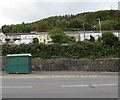
Row of houses behind Llwynypia Road, Llwynypia
Set back from the west side of the A4058 Llwynypia Road.
Image: © Jaggery
Taken: 2 Oct 2017
0.01 miles
2
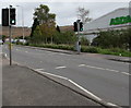
Pelican crossing, Llwynypia Road, Llwynypia
Across the A4058 Llwynypia Road. Chambers Dictionary states that pelican in this context is adapted from "pedestrian light controlled crossing".
Image: © Jaggery
Taken: 2 Oct 2017
0.03 miles
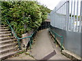
3
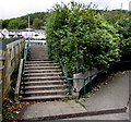
Steps up to Llwynypia Road, Llwynypia
An Asda superstore http://www.geograph.org.uk/photo/5557453 and a McDonald's http://www.geograph.org.uk/photo/5557459 are behind the camera.
Wheelchair users and other people unable to use the steps can use the ramp on the right.
Image: © Jaggery
Taken: 2 Oct 2017
0.04 miles
4
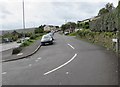
Unnamed side road, Llwynypia
Ascending from the A4058 Llwynypia Road. The sign on the right shows
ACCESS TO LLWYNYPIA TERRACE ROSEDALE TERRACE
ARGYLE TERRACE GRANGE TERRACE & HOLYROOD TERRACE.
Image: © Jaggery
Taken: 2 Oct 2017
0.04 miles
5
Ramp up to Llwynypia Road, Llwynypia
Giving an alternative to the steps access to Llwynypia Road.
An Asda superstore http://www.geograph.org.uk/photo/5557453 and a McDonald's http://www.geograph.org.uk/photo/5557459 are behind the camera.
Image: © Jaggery
Taken: 2 Oct 2017
0.04 miles
6
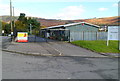
Rhondda Sea Cadets Corps compound, Llwynypia
The representation of anchors on the gates and the mast in the background are clues that the compound has a maritime connection. It is T.S. Minerva No. 485, http://www.geograph.org.uk/photo/2790919 used by Sea Cadets.
Image: © Jaggery
Taken: 28 Oct 2011
0.05 miles
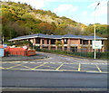
7
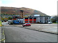
Tonypandy Fire Station
Viewed from Llwynypia Road, Llwynypia.
Part of the South Wales Fire and Rescue Service, Tonypandy Fire Station serves a part of the Rhondda Fawr Valley with an estimated population of 51,000. In addition to Tonypandy, locations covered include Pentre, Trebanog and Penrhiwfer. The station provides secondary fire cover to the retained station areas of Treorchy, Porth, Gilfach Goch and Ferndale. The station's responsibilities also cover large areas of densely planted forest, grass land and heath land.
Image: © Jaggery
Taken: 28 Oct 2011
0.05 miles
8
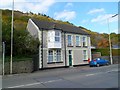
Former Llwynypia post office
Now divided into flats, number 21 Llwynypia Road was formerly a post office.
A wall-mounted red postbox http://www.geograph.org.uk/photo/5559042 remains as evidence of its former use.
Image: © Jaggery
Taken: 28 Oct 2011
0.06 miles
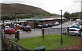
9
Former Rhondda Magistrates Court for sale, Llwynypia
View across Llwynypia Road. Rhondda Magistrates Court closed in May 2011. Staff and court services transferred to other courts in South Wales. The court’s closure was part of a nationwide reform, in which 103 magistrates courts were closed in England and Wales.
Image: © Jaggery
Taken: 28 Oct 2011
0.06 miles
10
McDonald's Llwynypia
Located below the east side of the A4058 Llwynypia Road.
Image: © Jaggery
Taken: 2 Oct 2017
0.06 miles