1
Pleasant Terrace, Clydach Vale
Row of houses north of Wern Street.
Image: © Jaggery
Taken: 5 Oct 2017
0.06 miles
2
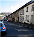
Oak Street, Clydach Vale
From the north side of Wern Street, Oak Street leads to Adams Street and Francis Street.
About 300 metres ahead, Oak Street ends at the edge of a stream, Nant Caedafydd.
Image: © Jaggery
Taken: 5 Oct 2017
0.08 miles
3
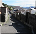
East along a Clydach Vale back lane
From Pleasant Terrace towards Oak Street.
Image: © Jaggery
Taken: 5 Oct 2017
0.09 miles
4
106-109 Wern Street, Clydach Vale
Four houses on the northeast side of the main east-west orientation of Wern Street.
Image: © Jaggery
Taken: 5 Oct 2017
0.10 miles
5
Wern Street houses, Clydach Vale
Above the north side of Wern Street, east of the Oak Street junction http://www.geograph.org.uk/photo/5561871 on the left.
Image: © Jaggery
Taken: 5 Oct 2017
0.10 miles
6
Ordnance Survey Cut Mark
This OS cut mark can be found at the junction of Wern Street & Oak Street. It marks a point 232.255m above mean sea level.
Image: © Adrian Dust
Taken: 13 May 2017
0.10 miles
7
Long row of houses, Wern Street, Clydach Vale
On the south side of Wern Street on the descent towards Tonypandy.
Image: © Jaggery
Taken: 5 Oct 2017
0.11 miles
8
On-street and on-pavement parking, High Street, Clydach Vale
Looking north along High Street towards Wern Street in October 2017.
This High Street is a quiet residential street with no shops, a most untypical UK High Street.
Image: © Jaggery
Taken: 5 Oct 2017
0.11 miles
9
Houses on the north side of Wern Street, Clydach Vale
The houses on the left are opposite the village primary school. http://www.geograph.org.uk/photo/5560154
Image: © Jaggery
Taken: 5 Oct 2017
0.11 miles
10
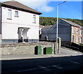
Telecoms cabinets on a Clydach Vale corner
On the Wern Street side of the corner of Oak Street.
The taller narrow BT cabinet is on the left, next to a Virgin Media cabinet.
Image: © Jaggery
Taken: 5 Oct 2017
0.11 miles


