IMAGES TAKEN NEAR TO
Georges Terrace, TONYPANDY, CF40 2AR
Introduction
This page details the photographs taken nearby to Georges Terrace, CF40 2AR by members of the Geograph project.
The Geograph project started in 2005 with the aim of publishing, organising and preserving representative images for every square kilometre of Great Britain, Ireland and the Isle of Man.

There are currently over 7.5m images from over14,400 individuals and you can help contribute to the project by visiting https://www.geograph.org.uk
Image Map
Images are licensed for reuse under creativecommons.org/licenses/by-sa/2.0
Notes
- Clicking on the map will re-center to the selected point.
- The higher the marker number, the further away the image location is from the centre of the postcode.
Image Listing (50 Images Found)
Images are licensed for reuse under creativecommons.org/licenses/by-sa/2.0
Image
Details
Distance
1
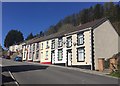
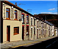
Dan-y-coed Terrace
Well maintained terraced houses in Tonypandy.
Image: © Alan Hughes
Taken: 11 Apr 2019
0.06 miles
2
Fern Terrace, Tonypandy
Ascending from the north side of Court Street.
Image: © Jaggery
Taken: 5 Oct 2017
0.07 miles
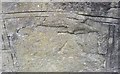
3

Ordnance Survey Cut Mark
This OS cut mark can be found on No1 Danycoed Terrace. It marks a point 208.822m above mean sea level.
Image: © Adrian Dust
Taken: 13 May 2017
0.07 miles
5
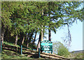
Ordnance Survey Cut Mark
This OS cut mark can be found on No91 Thomas Street. It marks a point 184.694m above mean sea level.
Image: © Adrian Dust
Taken: 13 May 2017
0.10 miles
6
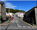
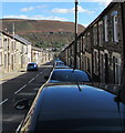
Waun Road, Tonypandy
Ascending towards Thomas Street and Charles Street from the north side of Court Street.
Image: © Jaggery
Taken: 5 Oct 2017
0.10 miles
7
Row of houses, Court Street, Tonypandy
On the north side of Court Street on the descent to the centre of Tonypandy.
Image: © Jaggery
Taken: 5 Oct 2017
0.11 miles
8
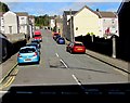
On-street parking, Court Street, Tonypandy
Cars are parked on the south side of Court Street.
Double yellow lines on the north side indicate no parking at any time.
Image: © Jaggery
Taken: 5 Oct 2017
0.12 miles
9
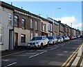
On-street parking, Court Street, Tonypandy
On the south side of Court Street on the descent to the centre of Tonypandy.
Double yellow lines indicate no parking on the north side of the street at any time.
A white cross is on the distant hillside.
Image: © Jaggery
Taken: 5 Oct 2017
0.12 miles
10
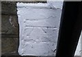
Ordnance Survey Cut Mark
This damaged OS cut mark can be found on the wall at the bottom of the steps on Maddox Street. It marks a point 213.595m above mean sea level.
Image: © Adrian Dust
Taken: 13 May 2017
0.13 miles