1
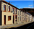
Row of houses, Court Street, Tonypandy
On the north side of Court Street on the descent to the centre of Tonypandy.
Image: © Jaggery
Taken: 5 Oct 2017
0.03 miles
2
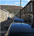
On-street parking, Court Street, Tonypandy
On the south side of Court Street on the descent to the centre of Tonypandy.
Double yellow lines indicate no parking on the north side of the street at any time.
A white cross is on the distant hillside.
Image: © Jaggery
Taken: 5 Oct 2017
0.03 miles
3
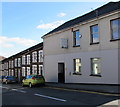
On-street parking, Court Street, Tonypandy
Cars are parked on the south side of Court Street.
Double yellow lines on the north side indicate no parking at any time.
Image: © Jaggery
Taken: 5 Oct 2017
0.04 miles
4
Waun Road, Tonypandy
Ascending towards Thomas Street and Charles Street from the north side of Court Street.
Image: © Jaggery
Taken: 5 Oct 2017
0.06 miles
5
Ordnance Survey Cut Mark
This OS cut mark can be found on No91 Thomas Street. It marks a point 184.694m above mean sea level.
Image: © Adrian Dust
Taken: 13 May 2017
0.06 miles
6
Entrance to the Monkey, Court Street, Tonypandy
The name sign http://www.geograph.org.uk/photo/5567348 shows MID RHONDDA WORKMEN'S CLUB ("THE MONKEY").
Image: © Jaggery
Taken: 5 Oct 2017
0.07 miles
7
Mid Rhondda Workmen's Club (The Monkey) name sign, Tonypandy
On a wall bracket here. http://www.geograph.org.uk/photo/5567347
Image: © Jaggery
Taken: 5 Oct 2017
0.07 miles
8
Staggered crossroads in Tonypandy
The main road is Court Street on the descent towards the centre of Tonypandy.
Fern Terrace http://www.geograph.org.uk/photo/5562494 is on the left. An unnamed road is on the right.
Image: © Jaggery
Taken: 5 Oct 2017
0.08 miles
9
Fern Terrace, Tonypandy
Ascending from the north side of Court Street.
Image: © Jaggery
Taken: 5 Oct 2017
0.09 miles
10
Detached and semi-detached in Court Street, Tonypandy
A detached house and two semi-detached houses are near the corner of Fern Terrace.
Image: © Jaggery
Taken: 5 Oct 2017
0.09 miles


