IMAGES TAKEN NEAR TO
Ardwyn Terrace, Penrhiwfer Road, TONYPANDY, CF40 1SF
Introduction
This page details the photographs taken nearby to Ardwyn Terrace, Penrhiwfer Road, CF40 1SF by members of the Geograph project.
The Geograph project started in 2005 with the aim of publishing, organising and preserving representative images for every square kilometre of Great Britain, Ireland and the Isle of Man.

There are currently over 7.5m images from over14,400 individuals and you can help contribute to the project by visiting https://www.geograph.org.uk
Image Map
Images are licensed for reuse under creativecommons.org/licenses/by-sa/2.0
Notes
- Clicking on the map will re-center to the selected point.
- The higher the marker number, the further away the image location is from the centre of the postcode.
Image Listing (54 Images Found)
Images are licensed for reuse under creativecommons.org/licenses/by-sa/2.0
Image
Details
Distance
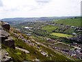
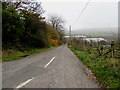
1
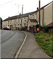
Houses at a bend in Penrhiwfer Road, Penrhiwfer
A detached house is nearest the camera. Behind it is a row of houses in Ardwyn Terrace.
Image: © Jaggery
Taken: 3 Nov 2017
0.02 miles
2
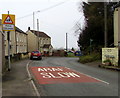
Warning sign - Patrol/Hebryngwr, Penrhiwfer Road, Penrhiwfer
The English/Welsh sign is on the approach to Penrhiwfer Infants School. http://www.geograph.org.uk/photo/5590065
Image: © Jaggery
Taken: 3 Nov 2017
0.02 miles
3
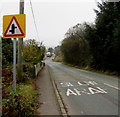
Warning sign - staggered crossroads ahead, Penrhiwfer
Alongside the B4278 Penrhiwfer Road near the southern edge of the village.
Image: © Jaggery
Taken: 3 Nov 2017
0.02 miles
6
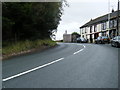
Penrhiwfer Infants School, Penrhiwfer
Viewed from Penrhiwfer Road.
Image: © Jaggery
Taken: 3 Nov 2017
0.04 miles
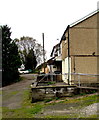
7
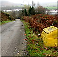
Yellow grit/salt box, Penrhiwfer
Alongside this https://www.geograph.org.uk/photo/5934834 unclassified road.
Image: © Jaggery
Taken: 3 Nov 2017
0.05 miles
9
Unclassified road descending from the B4278 in Penrhiwfer
Descending from the east side of the B4278 Penrhiwfer Road towards Office Row and Lewis Arms Row.
Image: © Jaggery
Taken: 3 Nov 2017
0.05 miles
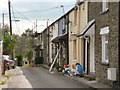
10
Lewis Arms Row houses, Penrhiwfer
Office Row houses are nearby. https://www.geograph.org.uk/photo/5934913
Image: © Jaggery
Taken: 3 Nov 2017
0.06 miles