IMAGES TAKEN NEAR TO
Pleasant View, TONYPANDY, CF40 1SB
Introduction
This page details the photographs taken nearby to Pleasant View, CF40 1SB by members of the Geograph project.
The Geograph project started in 2005 with the aim of publishing, organising and preserving representative images for every square kilometre of Great Britain, Ireland and the Isle of Man.

There are currently over 7.5m images from over14,400 individuals and you can help contribute to the project by visiting https://www.geograph.org.uk
Image Map
Images are licensed for reuse under creativecommons.org/licenses/by-sa/2.0
Notes
- Clicking on the map will re-center to the selected point.
- The higher the marker number, the further away the image location is from the centre of the postcode.
Image Listing (47 Images Found)
Images are licensed for reuse under creativecommons.org/licenses/by-sa/2.0
Image
Details
Distance
1
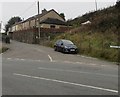
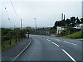
Pleasant View, Penrhiwfer
Viewed across the B4278 Penrhiwfer Road. The Pleasant View name sign is on the right.
Image: © Jaggery
Taken: 3 Nov 2017
0.00 miles
2
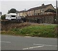
Pleasant View houses, Penrhiwfer
Above the B4278 Penrhiwfer Road.
Image: © Jaggery
Taken: 3 Nov 2017
0.01 miles
3
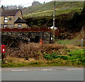
Queen Elizabeth II postbox in Penrhiwfer
On the west side of the B4278 Penrhiwfer Road.
Image: © Jaggery
Taken: 3 Nov 2017
0.03 miles
4
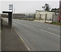
Bus stop and shelter at the southern edge of Penrhiwfer
Alongside the B4278 Penrhiwfer Road opposite houses in Pleasant View.
Image: © Jaggery
Taken: 3 Nov 2017
0.03 miles
5
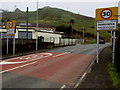
Welcome/Croeso Penrhiwfer
The National Speed Limit on the B4278 Penrhiwfer Road from Tonyrefail drops to 30mph at the southern edge of Penrhiwfer, a small village in the County Borough of Rhondda Cynon Taf.
Image: © Jaggery
Taken: 3 Nov 2017
0.03 miles
6
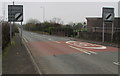
End of the 30 zone at the southern edge of Penrhiwfer
The 30mph speed limit on the B4278 Penrhiwfer Road increases to the National Speed Limit beyond the southern edge of Penrhiwfer, a small village in the County Borough of Rhondda Cynon Taf.
Image: © Jaggery
Taken: 3 Nov 2017
0.03 miles
8
Office Row and Lewis Arms Row direction sign, Penrhiwfer
The black arrow on the sign facing the B4278 Penrhiwfer Road points left towards this https://www.geograph.org.uk/photo/5934834 unclassified road.
Image: © Jaggery
Taken: 3 Nov 2017
0.04 miles
9
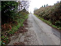
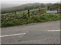
Unclassified road in Penrhiwfer
Ascending towards the B4278 Penrhiwfer Road.
Image: © Jaggery
Taken: 3 Nov 2017
0.04 miles
10
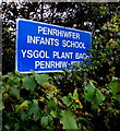
Bilingual school name sign, Penrhiwfer
The sign shows that Penrhiwfer Infants School http://www.geograph.org.uk/photo/5590065 is Ysgol Plant Bach Penrhiw-fer in Welsh.
Image: © Jaggery
Taken: 3 Nov 2017
0.05 miles