IMAGES TAKEN NEAR TO
Church Road, TONYPANDY, CF40 1RY
Introduction
This page details the photographs taken nearby to Church Road, CF40 1RY by members of the Geograph project.
The Geograph project started in 2005 with the aim of publishing, organising and preserving representative images for every square kilometre of Great Britain, Ireland and the Isle of Man.

There are currently over 7.5m images from over14,400 individuals and you can help contribute to the project by visiting https://www.geograph.org.uk
Image Map
Images are licensed for reuse under creativecommons.org/licenses/by-sa/2.0
Notes
- Clicking on the map will re-center to the selected point.
- The higher the marker number, the further away the image location is from the centre of the postcode.
Image Listing (112 Images Found)
Images are licensed for reuse under creativecommons.org/licenses/by-sa/2.0
Image
Details
Distance
1
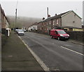
Up Church Road, Penrhiwfer
Church Road ascends towards the road named Cae Glas.
Image: © Jaggery
Taken: 3 Nov 2017
0.02 miles
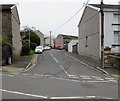
2
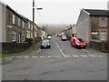
West along Church Road, Penrhiwfer
From the corner of Greenmeadow Terrace along Church Road towards Cae Glas.
Image: © Jaggery
Taken: 3 Nov 2017
0.03 miles
3
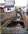
Infant River Ely, Penrhiwfer
Here less than a mile (c1.6km) from its source, the Ely (Afon Elái in Welsh)
flows towards a culvert under the B4278 Penrhiwfer Road.
Image: © Jaggery
Taken: 3 Nov 2017
0.03 miles
4
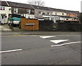
Meyricks Row, Penrhiwfer
Row of houses set back from the west side of the B4278 Penrhiwfer Road.
Image: © Jaggery
Taken: 3 Nov 2017
0.03 miles

6
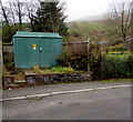
Electricity substation, Cae Glas, Penrhiwfer
The green cabinet is a Western Power Distribution electricity substation.
Image: © Jaggery
Taken: 3 Nov 2017
0.04 miles
7
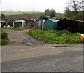
Lockup garages, Penrhiwfer
Set back from the south side of Church Road and Cae Glas.
Image: © Jaggery
Taken: 3 Nov 2017
0.04 miles
8
Junction of Church Road and Penrhiwfer Road, Penrhiwfer
The eastern end of Church Road viewed across the B4278 Penrhiwfer Road.
Image: © Jaggery
Taken: 3 Nov 2017
0.04 miles
9
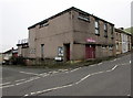
Penrhiwfer Community Centre, Penrhiwfer
On the corner of Penrhiwfer Road and Ashdale Road.
Image: © Jaggery
Taken: 3 Nov 2017
0.05 miles
10
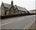
St Illtyd's Church, Williamstown
Church in Wales church in the Diocese of Llandaff viewed across the B4278 Penrhiwfer Road.
Though the church is known as St Illtyd's Church Williamstown, it is located
in Penrhiwfer south of Williamstown. The building was erected in the 1890s.
Image: © Jaggery
Taken: 3 Nov 2017
0.05 miles