IMAGES TAKEN NEAR TO
Haul Fron, TONYPANDY, CF40 1RH
Introduction
This page details the photographs taken nearby to Haul Fron, CF40 1RH by members of the Geograph project.
The Geograph project started in 2005 with the aim of publishing, organising and preserving representative images for every square kilometre of Great Britain, Ireland and the Isle of Man.

There are currently over 7.5m images from over14,400 individuals and you can help contribute to the project by visiting https://www.geograph.org.uk
Image Map
Images are licensed for reuse under creativecommons.org/licenses/by-sa/2.0
Notes
- Clicking on the map will re-center to the selected point.
- The higher the marker number, the further away the image location is from the centre of the postcode.
Image Listing (136 Images Found)
Images are licensed for reuse under creativecommons.org/licenses/by-sa/2.0
Image
Details
Distance
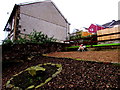
1
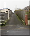
Back lane on the south side of Cae Glas, Williamstown
Past the backs of houses on the west side of Greenmeadow Terrace, the lane leads to Church Road.
Image: © Jaggery
Taken: 3 Nov 2017
0.02 miles
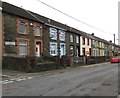
2
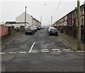
Row of houses, Cae Glas, Williamstown
Extending for 45 metres along the south side of the road named Cae Glas.
Image: © Jaggery
Taken: 3 Nov 2017
0.03 miles
3
Greenmeadow Terrace, Williamstown
Ascending from the south side of the road named Cae Glas.
Image: © Jaggery
Taken: 3 Nov 2017
0.04 miles
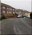
4
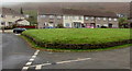
Row of houses behind a green, Cae Glas, Williamstown
Cae Glas is an area of houses west of the B4278 Penrhiwfer Road.
Image: © Jaggery
Taken: 3 Nov 2017
0.05 miles
5

Road into Ely Industrial Estate, Williamstown
From the B4278.
Image: © Jaggery
Taken: 3 Nov 2017
0.06 miles
6
Telecoms cabinets, Cae Glas, Williamstown
A BT cabinet is on the left. Numbered 22, a Virgin Media cabinet is on the corner of Greenmeadow Terrace.
Image: © Jaggery
Taken: 3 Nov 2017
0.06 miles
7
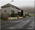
West side of Greenmeadow Terrace, Penrhiwfer
Viewed from Church Road.
Image: © Jaggery
Taken: 3 Nov 2017
0.06 miles
8
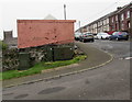
Rhymney Brewery Hobby Horse trademark in Williamstown
In a 20 metre gap between buildings on the west side of Penrhiwfer Road, which suggests that this could be the site of a demolished pub. The Hobby Horse trademark can be seen in other locations in South Wales, such as in Manmoel. http://www.geograph.org.uk/photo/637187
Image: © Jaggery
Taken: 3 Nov 2017
0.06 miles
9
Bend in the road, Cae Glas, Penrhiwfer
Viewed from the western end of Church Road.
Image: © Jaggery
Taken: 3 Nov 2017
0.07 miles
10
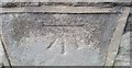
Ordnance Survey Cut Mark
This OS cut mark can be found on No30 Penrhiwfer Road. It marks a point 195.165m above mean sea level.
Image: © Adrian Dust
Taken: 21 May 2017
0.07 miles