IMAGES TAKEN NEAR TO
Cornwall Road, TONYPANDY, CF40 1PS
Introduction
This page details the photographs taken nearby to Cornwall Road, CF40 1PS by members of the Geograph project.
The Geograph project started in 2005 with the aim of publishing, organising and preserving representative images for every square kilometre of Great Britain, Ireland and the Isle of Man.

There are currently over 7.5m images from over14,400 individuals and you can help contribute to the project by visiting https://www.geograph.org.uk
Image Map
Images are licensed for reuse under creativecommons.org/licenses/by-sa/2.0
Notes
- Clicking on the map will re-center to the selected point.
- The higher the marker number, the further away the image location is from the centre of the postcode.
Image Listing (144 Images Found)
Images are licensed for reuse under creativecommons.org/licenses/by-sa/2.0
Image
Details
Distance
1
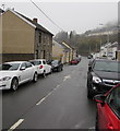
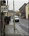
On-street parking, Cornwall Road, Williamstown
Looking north from the corner of Brook Street.
Image: © Jaggery
Taken: 26 Oct 2017
0.03 miles
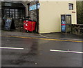
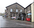
2
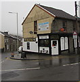
Former Williamstown Post Office
In October 2017, the Williamstown Post Office name sign remains on the building on the corner of Brook Street and Cornwall Road, now the premises of Coffee @ Cafe which sells coffee and hot or cold food. The current village post office is inside Quick Stop http://www.geograph.org.uk/photo/5579970 at 28-30 Brook Street.
Image: © Jaggery
Taken: 26 Oct 2017
0.04 miles
3
Black Diamond Edmondstown advert in Williamstown
The banner on a Brook Street building in Williamstown is for the Black Diamond http://www.geograph.org.uk/photo/5585675 in Edmondstown
about a kilometre behind the camera. The grey back of this http://www.geograph.org.uk/photo/5581314 old-style sign is on the left.
Image: © Jaggery
Taken: 26 Oct 2017
0.04 miles
4
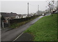
Narrow side road north of Arthur Street, Williamstown
Leading to Mountain Road.
Image: © Jaggery
Taken: 26 Oct 2017
0.04 miles
5
Old-style direction sign, Brook Street, Williamstown
A rare survivor from before 1965 viewed in October 2017.
Image: © Jaggery
Taken: 26 Oct 2017
0.04 miles
6
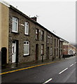
Short row of stone houses, Brook Street, Williamstown
Viewed across the B4278 Brook Street from the corner of Cornwall Road.
Image: © Jaggery
Taken: 26 Oct 2017
0.05 miles
7
Black dragon depiction on a Brook Street wall, Williamstown
On a wall of the Glamorgan bar & grill. http://www.geograph.org.uk/photo/5581296
Image: © Jaggery
Taken: 26 Oct 2017
0.05 miles
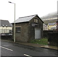
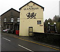
8
BT phonebox, Brook Street, Williamstown
Located here http://www.geograph.org.uk/photo/5581300 outside the Glamorgan bar & grill.
Image: © Jaggery
Taken: 26 Oct 2017
0.05 miles
9
North side of The Glamorgan, Brook Street, Williamstown
This side of the Glamorgan bar & grill is opposite the Cornwall Road junction.
http://www.geograph.org.uk/photo/5581293 to the east side of The Glamorgan.
Image: © Jaggery
Taken: 26 Oct 2017
0.05 miles
10
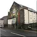
Penygraig Boys & Girls Club, Brook Street, Williamstown
The building used to be Williamstown Methodist Chapel which was built in 1894.
Image: © Jaggery
Taken: 26 Oct 2017
0.05 miles