IMAGES TAKEN NEAR TO
Hendre Terrace, TONYPANDY, CF40 1PL
Introduction
This page details the photographs taken nearby to Hendre Terrace, CF40 1PL by members of the Geograph project.
The Geograph project started in 2005 with the aim of publishing, organising and preserving representative images for every square kilometre of Great Britain, Ireland and the Isle of Man.

There are currently over 7.5m images from over14,400 individuals and you can help contribute to the project by visiting https://www.geograph.org.uk
Image Map
Images are licensed for reuse under creativecommons.org/licenses/by-sa/2.0
Notes
- Clicking on the map will re-center to the selected point.
- The higher the marker number, the further away the image location is from the centre of the postcode.
Image Listing (183 Images Found)
Images are licensed for reuse under creativecommons.org/licenses/by-sa/2.0
Image
Details
Distance
1
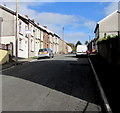
Library Road, Penygraig
From Amos Hill, Library Road ascends towards Belle Vue Park.
Image: © Jaggery
Taken: 20 Oct 2017
0.03 miles
2
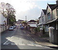
Up Park Road, Penygraig
From the south side of Vicarage Road, Park Road ascends towards Belle Vue Park.
Image: © Jaggery
Taken: 17 Oct 2017
0.05 miles
3
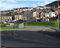
Towards Amos Hill, Penygraig
Viewed from the corner of the B4278 and Pleasant Road looking towards Amos Hill houses.
Image: © Jaggery
Taken: 20 Oct 2017
0.06 miles
4
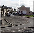
Amos Hill, Penygraig
Ascending from the corner of Swan Terrace.
Image: © Jaggery
Taken: 20 Oct 2017
0.07 miles
5
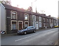
Swan Terrace, Penygraig
Row of houses viewed across the B4278, here named Swan Terrace.
Image: © Jaggery
Taken: 17 Oct 2017
0.07 miles
6
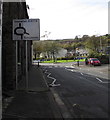
Directions sign facing Swan Terrace, Penygraig
On the approach to the roundabout at the B4278 junction.
Image: © Jaggery
Taken: 20 Oct 2017
0.07 miles
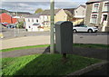
7
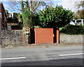
Brick urinal, Swan Terrace, Penygraig
The brick structure is a basic urinal (no pedestals or wash basins), available 24 hours a day, 7 days a week. Though such facilities have largely disappeared from many parts of South Wales, basic urinals (of varying designs) remain a common sight here in the Rhondda in 2017.
Image: © Jaggery
Taken: 20 Oct 2017
0.07 miles
8
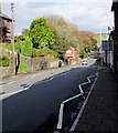
Down Swan Terrace, Penygraig
Swan Terrace descends from the roundabout at the B4278 junction.
The zigzag white lines mark the Keep Clear Zone on the approach to this http://www.geograph.org.uk/photo/5574949 zebra crossing.
Image: © Jaggery
Taken: 20 Oct 2017
0.07 miles
10
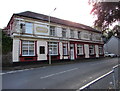
White Rock Hotel, Penygraig
Pub viewed across the B4278 Dinas Road.
Image: © Jaggery
Taken: 17 Oct 2017
0.07 miles