IMAGES TAKEN NEAR TO
Edmondstown, TONYPANDY, CF40 1NU
Introduction
This page details the photographs taken nearby to Edmondstown, CF40 1NU by members of the Geograph project.
The Geograph project started in 2005 with the aim of publishing, organising and preserving representative images for every square kilometre of Great Britain, Ireland and the Isle of Man.

There are currently over 7.5m images from over14,400 individuals and you can help contribute to the project by visiting https://www.geograph.org.uk
Image Map
Images are licensed for reuse under creativecommons.org/licenses/by-sa/2.0
Notes
- Clicking on the map will re-center to the selected point.
- The higher the marker number, the further away the image location is from the centre of the postcode.
Image Listing (54 Images Found)
Images are licensed for reuse under creativecommons.org/licenses/by-sa/2.0
Image
Details
Distance
1
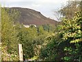
Across the Rhondda from Penrhiwfer
This view is toward Mynydd Dinas from a footpath leading down from Lewi Arms Row.
Image: © Mick Lobb
Taken: 25 Sep 2008
0.08 miles
2
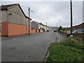
Rhys Street, Edmondstown
From the corner of Weston Terrace.
Image: © Jaggery
Taken: 31 Oct 2017
0.09 miles
3

Old People's Welfare Hall, Edmondstown
Between Edmondstown Road and Rhys Street.
Image: © Jaggery
Taken: 16 Nov 2017
0.11 miles
4
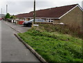
Rhys Street bungalows, Edmondstown
On the right here. http://www.geograph.org.uk/photo/5585438
Image: © Jaggery
Taken: 31 Oct 2017
0.11 miles
5
Modern houses, Rhys Street, Edmondstown
Viewed from Edmondstown Road.
Image: © Jaggery
Taken: 31 Oct 2017
0.11 miles
6
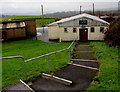
Steps down to Edmondstown Old People's Welfare Hall
From an Edmondstown Road bus stop in Edmondstown.
Image: © Jaggery
Taken: 16 Nov 2017
0.11 miles
7
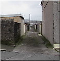
Back lane on the east side of Weston Terrace, Edmondstown
Towards Rhys Street.
Image: © Jaggery
Taken: 31 Oct 2017
0.11 miles
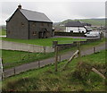
8
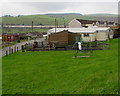
Children's playground, Edmondstown
Between Edmondstown Road and Rhys Street.
Image: © Jaggery
Taken: 31 Oct 2017
0.12 miles
9
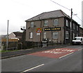
Black Diamond, Edmondstown Road, Edmondstown
Some references state that the Black Diamond is a pub or hotel,
but text on windows on October 31st 2017 shows Black Diamond Tea Room.
Image: © Jaggery
Taken: 31 Oct 2017
0.12 miles
10
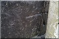
Ordnance Survey Cut Mark
This OS cut mark can be found on the Black Diamond PH. It marks a point 215.029m above mean sea level.
Image: © Adrian Dust
Taken: 21 May 2017
0.12 miles