IMAGES TAKEN NEAR TO
Hendrecafn Road, TONYPANDY, CF40 1LJ
Introduction
This page details the photographs taken nearby to Hendrecafn Road, CF40 1LJ by members of the Geograph project.
The Geograph project started in 2005 with the aim of publishing, organising and preserving representative images for every square kilometre of Great Britain, Ireland and the Isle of Man.

There are currently over 7.5m images from over14,400 individuals and you can help contribute to the project by visiting https://www.geograph.org.uk
Image Map
Images are licensed for reuse under creativecommons.org/licenses/by-sa/2.0
Notes
- Clicking on the map will re-center to the selected point.
- The higher the marker number, the further away the image location is from the centre of the postcode.
Image Listing (171 Images Found)
Images are licensed for reuse under creativecommons.org/licenses/by-sa/2.0
Image
Details
Distance
1
Penygraig public conveniences
Public toilets on the west side of Tylacelyn Road near the corner of Hendrecafn Road in Penygraig.
Image: © Jaggery
Taken: 17 Oct 2017
0.03 miles
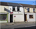
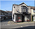
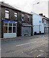
2
Trevor's Graphics shop, Penygraig
In Hendrecafn Road, viewed across Tylacelyn Road.
Image: © Jaggery
Taken: 17 Oct 2017
0.03 miles
3
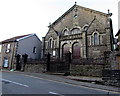
Pisgah Chapel, Tylacelyn Road, Penygraig
Built in 1868. Grade II listed in 1996.
Image: © Jaggery
Taken: 17 Oct 2017
0.03 miles
4
Rhondda Animals in Need shop, Tylacelyn Road, Penygraig
Near the corner of Hendrecafn Road. Rhondda Animals in Need is a small
rescue group for abandoned and unwanted animals in the Rhondda area.
Image: © Jaggery
Taken: 17 Oct 2017
0.04 miles
5
Newman Photography in Penygraig
Located in Penygraig Studios at 89 Tylacelyn Road on the corner of Hendrecafn Road.
Image: © Jaggery
Taken: 17 Oct 2017
0.04 miles
6
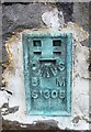
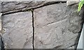
Ordnance Survey Flush Bracket (S1305)
This OS Flush Bracket can be found on the east face of the school. It marks a point 161.226m above mean sea level.
Image: © Adrian Dust
Taken: 21 May 2017
0.04 miles
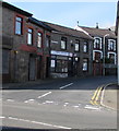
7
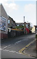
Station Street, Penygraig
Ascending from Tylacelyn Road towards Hughes Street and Hendrecafn Road.
It's many decades since a railway station was nearby. Penygraig station closed in 1930.
Image: © Jaggery
Taken: 17 Oct 2017
0.04 miles
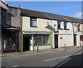
8
J.R. Video Service shop in Penygraig
On the east side of Tylacelyn Road.
Image: © Jaggery
Taken: 17 Oct 2017
0.04 miles
9
Ordnance Survey Cut Mark
This OS cut mark can be found on No47A Tylacelyn Road. It marks a point 156.615m above mean sea level.
Image: © Adrian Dust
Taken: 21 May 2017
0.04 miles
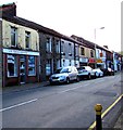
10
Pen-y-bike and Co-op, Penygraig
On the east side of Tylacelyn Road. Co-op on the right is on the corner of Glannant Street.
Image: © Jaggery
Taken: 17 Oct 2017
0.04 miles