IMAGES TAKEN NEAR TO
Tylacelyn Road, TONYPANDY, CF40 1JR
Introduction
This page details the photographs taken nearby to Tylacelyn Road, CF40 1JR by members of the Geograph project.
The Geograph project started in 2005 with the aim of publishing, organising and preserving representative images for every square kilometre of Great Britain, Ireland and the Isle of Man.

There are currently over 7.5m images from over14,400 individuals and you can help contribute to the project by visiting https://www.geograph.org.uk
Image Map
Images are licensed for reuse under creativecommons.org/licenses/by-sa/2.0
Notes
- Clicking on the map will re-center to the selected point.
- The higher the marker number, the further away the image location is from the centre of the postcode.
Image Listing (226 Images Found)
Images are licensed for reuse under creativecommons.org/licenses/by-sa/2.0
Image
Details
Distance
1
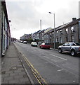
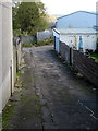
Up Tylacelyn Road, Penygraig
Part of Tylacelyn Road's long ascent away from the Rhondda River (Afon Rhondda Fawr in Welsh).
Image: © Jaggery
Taken: 17 Oct 2017
0.01 miles
2
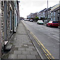
Pavement and doorsteps, Tylacelyn Road, Penygraig
On the west side of Tylacelyn Road on the long ascent from the Rhondda River (Afon Rhondda Fawr in Welsh).
Image: © Jaggery
Taken: 17 Oct 2017
0.01 miles
3
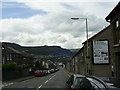
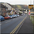
Tylacelyn Road near Penygraig
The view along Tylacelyn Road towards Tonypandy.
Image: © Martyn Harries
Taken: 6 Aug 2011
0.02 miles
4
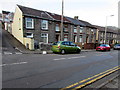
On-street parking, Tylacelyn Road, Penygraig
Parking allowed on the west side of the road.
Double yellow lines on the east side indicate no parking at any time.
The corner of an unnamed side street http://www.geograph.org.uk/photo/5577040 is on the left.
Image: © Jaggery
Taken: 17 Oct 2017
0.03 miles
5
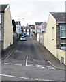
Unnamed side road in Penygraig
From the east side of Tylacelyn Road towards the southwest corner of Graig Park (out of shot on the left), the home ground of Penygraig RFC (Rugby Football Club).
Image: © Jaggery
Taken: 17 Oct 2017
0.03 miles
6
Yellow speed camera, Tylacelyn Road, Penygraig
Facing northbound traffic (towards Tonypandy).
Image: © Jaggery
Taken: 17 Oct 2017
0.04 miles
7
Steep ascent from Tylacelyn Road, Penygraig
An unnamed side street ascends from Tylacelyn Road to Hughes Street.
Image: © Jaggery
Taken: 17 Oct 2017
0.04 miles
8
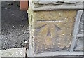
Ordnance Survey Cut Mark
This OS cut mark can be found on No30 Tylacelyn Road. It marks a point 153.110m above mean sea level.
Image: © Adrian Dust
Taken: 21 May 2017
0.06 miles
9
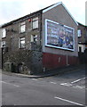
Barclaycard advert on a Penygraig corner
On October 17th 2017 a Barclaycard advert is on the Clear Channel
board on the Station Street side of the Tylacelyn Road corner.
Image: © Jaggery
Taken: 17 Oct 2017
0.06 miles
10
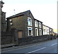
West side of Tylacelyn Road, Penygraig
Houses between Pisgah chapel http://www.geograph.org.uk/photo/5571816 on the left and Station Street.
Image: © Jaggery
Taken: 17 Oct 2017
0.06 miles