IMAGES TAKEN NEAR TO
Hendre Gwilym, TONYPANDY, CF40 1HE
Introduction
This page details the photographs taken nearby to Hendre Gwilym, CF40 1HE by members of the Geograph project.
The Geograph project started in 2005 with the aim of publishing, organising and preserving representative images for every square kilometre of Great Britain, Ireland and the Isle of Man.

There are currently over 7.5m images from over14,400 individuals and you can help contribute to the project by visiting https://www.geograph.org.uk
Image Map
Images are licensed for reuse under creativecommons.org/licenses/by-sa/2.0
Notes
- Clicking on the map will re-center to the selected point.
- The higher the marker number, the further away the image location is from the centre of the postcode.
Image Listing (117 Images Found)
Images are licensed for reuse under creativecommons.org/licenses/by-sa/2.0
Image
Details
Distance
1
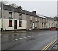
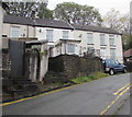
Row of houses, Penygraig Road, Penygraig
Extending for 40 metres along the west side of the B4278 Penygraig Road.
Image: © Jaggery
Taken: 26 Oct 2017
0.04 miles
2
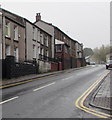
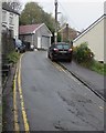
Up Penygraig Road, Penygraig
The B4278 Penygraig Road ascends towards Williamstown. Viewed from the corner of Gethin Road.
Image: © Jaggery
Taken: 26 Oct 2017
0.04 miles
3
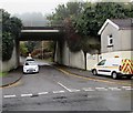
This way to Hendregwilym, Penygraig
From the B4278 Penygraig Road, the side road under the A4119 bridge leads to houses in Hendregwilym.
Image: © Jaggery
Taken: 26 Oct 2017
0.05 miles
4
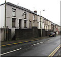
Houses above Penygraig Road, Penygraig
These houses on the west side of the B4278 Penygraig Road are set a couple of metres above road level, accessed via steps.
Image: © Jaggery
Taken: 26 Oct 2017
0.05 miles
5
Gethin Road houses, Penygraig
Viewed from the corner of Penygraig Road.
Image: © Jaggery
Taken: 26 Oct 2017
0.05 miles
6
Gethin Road, Penygraig
Narrow road ascending from Penygraig Road.
Image: © Jaggery
Taken: 26 Oct 2017
0.06 miles
7
Two brick semis, Penygraig Road, Penygraig
Two semi-detached houses on the east side of Penygraig Road opposite Gethin Road.
Image: © Jaggery
Taken: 26 Oct 2017
0.06 miles
8
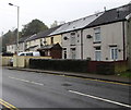
Row of houses, Penygraig Road, Penygraig
Looking towards the Williamstown boundary just out of shot ahead. The row is not parallel with Penygraig Road - houses on the left have bigger front gardens than houses on the right.
Image: © Jaggery
Taken: 26 Oct 2017
0.06 miles
9
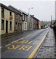
Up Penygraig Road, Penygraig
The B4278 Penygraig Road ascends towards Williamstown and Tonypandy.
Image: © Jaggery
Taken: 26 Oct 2017
0.06 miles
10
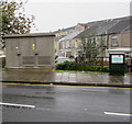
Two cabinets alongside Penygraig Road, Penygraig
Western Power Distribution electricity substation on the left, BT telecoms cabinet on the right.
Image: © Jaggery
Taken: 26 Oct 2017
0.07 miles