IMAGES TAKEN NEAR TO
Bryn Terrace, PORTH, CF39 9UR
Introduction
This page details the photographs taken nearby to Bryn Terrace, CF39 9UR by members of the Geograph project.
The Geograph project started in 2005 with the aim of publishing, organising and preserving representative images for every square kilometre of Great Britain, Ireland and the Isle of Man.

There are currently over 7.5m images from over14,400 individuals and you can help contribute to the project by visiting https://www.geograph.org.uk
Image Map
Images are licensed for reuse under creativecommons.org/licenses/by-sa/2.0
Notes
- Clicking on the map will re-center to the selected point.
- The higher the marker number, the further away the image location is from the centre of the postcode.
Image Listing (218 Images Found)
Images are licensed for reuse under creativecommons.org/licenses/by-sa/2.0
Image
Details
Distance
2
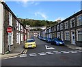
Cross Street, Porth
From the corner of John Street along Cross Street to North Road.
Image: © Jaggery
Taken: 5 Oct 2017
0.06 miles
3
Edward Street, Porth
From Syphon Street along Edward Street towards North Road viewed in October 2017. Edward Street has become a one-way street since September 2012 when a Google Earth Street View shows no No Entry sign here.
Image: © Jaggery
Taken: 5 Oct 2017
0.06 miles
4
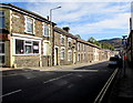
North Street, Porth
Ahead is a one-way section of the B4278. Silver Star takeaway http://www.geograph.org.uk/photo/5562128 is on the left.
Image: © Jaggery
Taken: 5 Oct 2017
0.06 miles
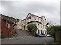
5
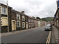
North Rd, Porth
The houses are numbered consecutively along the north side of the street from west to east, then back along the south side from east to west, so that Nos 1 and 123 (Humphreys Funeral Directors, purple sign on the right of the picture) are opposite each other.
Image: © John Lord
Taken: 12 Jul 2016
0.07 miles
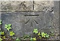
6
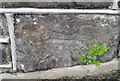
Ordnance Survey Cut Mark
This OS cut mark can be found on the wall of No2 Penrhiwgwynt Road. It marks a point 132.289m above mean sea level.
Image: © Adrian Dust
Taken: 4 Jun 2017
0.08 miles
8
Ordnance Survey Cut Mark
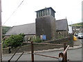
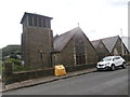
This OS cut mark can be found on the SE face of St Paul's Church. It marks a point 112.645m above mean sea level.
Image: © Adrian Dust
Taken: 4 Jun 2017
0.08 miles