IMAGES TAKEN NEAR TO
Lewis Terrace, PORTH, CF39 9TY
Introduction
This page details the photographs taken nearby to Lewis Terrace, CF39 9TY by members of the Geograph project.
The Geograph project started in 2005 with the aim of publishing, organising and preserving representative images for every square kilometre of Great Britain, Ireland and the Isle of Man.

There are currently over 7.5m images from over14,400 individuals and you can help contribute to the project by visiting https://www.geograph.org.uk
Image Map
Images are licensed for reuse under creativecommons.org/licenses/by-sa/2.0
Notes
- Clicking on the map will re-center to the selected point.
- The higher the marker number, the further away the image location is from the centre of the postcode.
Image Listing (25 Images Found)
Images are licensed for reuse under creativecommons.org/licenses/by-sa/2.0
Image
Details
Distance
1
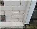
Ordnance Survey Cut Mark
This OS cut mark can be found on No30 Nythbran Terrace. It marks a point 117.021m above mean sea level.
Image: © Adrian Dust
Taken: 3 Mar 2021
0.09 miles
2
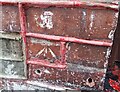
Ordnance Survey Cut Mark
This OS cut mark can be found on No83 Nythbran Terrace. It marks a point 127.147m above mean sea level.
Image: © Adrian Dust
Taken: 3 Mar 2021
0.11 miles
9
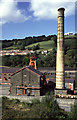
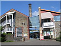
Lewis merthyr Colliery
Very nice but long disused chimney. The winding engine latterly used compressed air that was produced up the valley at Ty Mawr Colliery
Image: © Chris Allen
Taken: 1 Oct 1995
0.22 miles
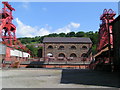
10
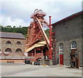
Winding wheels, Rhondda Heritage Park, Trehafod
The heritage park was formerly Lewis Merthyr colliery. This view of the central section of the heritage park shows the winding wheels and supporting structures above one of the two shafts that descended to the mining area.
Image: © Jaggery
Taken: 6 May 2011
0.22 miles