IMAGES TAKEN NEAR TO
Waun-Wen, PORTH, CF39 9LX
Introduction
This page details the photographs taken nearby to Waun-Wen, CF39 9LX by members of the Geograph project.
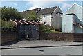
The Geograph project started in 2005 with the aim of publishing, organising and preserving representative images for every square kilometre of Great Britain, Ireland and the Isle of Man.

There are currently over 7.5m images from over14,400 individuals and you can help contribute to the project by visiting https://www.geograph.org.uk
Image Map
Images are licensed for reuse under creativecommons.org/licenses/by-sa/2.0
Notes
- Clicking on the map will re-center to the selected point.
- The higher the marker number, the further away the image location is from the centre of the postcode.
Image Listing (101 Images Found)
Images are licensed for reuse under creativecommons.org/licenses/by-sa/2.0
Image
Details
Distance
1
Rhiw Garn electricity substation, Trebanog
The identifier on the Western Power Distribution electricity substation inside an enclosure is
RHIW GARN TREBANOG S/S 542286.
Image: © Jaggery
Taken: 30 Jul 2014
0.02 miles
2
Trebanog and District Tenants and Residents Association
The Association building is on the corner of Rhiwgarn and Pen y dre in Trebanog.
Image: © Jaggery
Taken: 30 Jul 2014
0.03 miles
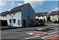
3
Unnamed shop in Trebanog
On the corner of Rhiwgarn and Waun Wen.
Image: © Jaggery
Taken: 30 Jul 2014
0.04 miles
4
Pen y dre, Trebanog
100 metre long cul-de-sac on the south side of Rhiwgarn.
Image: © Jaggery
Taken: 30 Jul 2014
0.04 miles
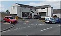
5
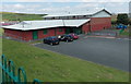
Waunwen Community Recreation Centre, Trebanog
Viewed from Rhiwgarn.
Image: © Jaggery
Taken: 30 Jul 2014
0.06 miles
6
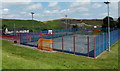
Multi-use sports court, Trebanog
Located west of the Waunwen Community Recreation Centre building. http://www.geograph.org.uk/photo/4096994
Several sports can be played here, monitored by CCTV cameras high up on poles.
Image: © Jaggery
Taken: 30 Jul 2014
0.06 miles
7
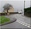
Bend in Rhiwgarn, Trebanog
Viewed from the corner of Cefn Bryn. The white van is approaching the Pen y Banc junction.
Image: © Jaggery
Taken: 16 Nov 2017
0.07 miles
8
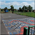
Snakes and ladders play area outside Waunwen Community Recreation Centre, Trebanog
Visible in the background here. http://www.geograph.org.uk/photo/4096994
Image: © Jaggery
Taken: 30 Jul 2014
0.07 miles
9
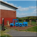
Blue corner of Waunwen Community Recreation Centre, Trebanog
Visible in a play area in the background here. http://www.geograph.org.uk/photo/4096994 Local five year olds are unlikely to have seen a real steam locomotive, but may have watched Thomas the Tank Engine on television, so perhaps have an idea what this play area represents.
Image: © Jaggery
Taken: 30 Jul 2014
0.07 miles
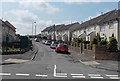
10
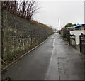
Back lane in Trebanog
From the south side of Rhiwgarn past the backs of houses on the east side of Trebanog Road.
Image: © Jaggery
Taken: 16 Nov 2017
0.07 miles