1
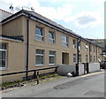
St. John's Street, Cymmer
A particularly bright row of terraced housing. They also look a bit bigger than usual and by their location up the hillside may be 1930s and have belonged to the first line supervisory staff.
Image: © Graham Horn
Taken: 4 Oct 2008
0.04 miles
2
Ordnance Survey Cut Mark
This OS cut mark can be found on the east face of No1 Cross Street. It marks a point 117.238m above mean sea level.
Image: © Adrian Dust
Taken: 4 Jun 2017
0.05 miles
3
A4233 at Porth
Image: © Colin Pyle
Taken: 9 Sep 2011
0.08 miles
4
Turning for Pontypridd
Image: © Roger Cornfoot
Taken: 3 Apr 2017
0.08 miles
5
A4233 heads east away from Cymmer, Porth
Destinations shown on the sign on the left are Aberdare, Pontypridd and Porth town centre.
Image: © Jaggery
Taken: 30 Jul 2014
0.10 miles
6
Morrisons Porth viewed from the far end of the car park
The car park occupies about three-quarters of the land at the supermarket site on the west bank of the River Rhondda in central Porth.
Image: © Jaggery
Taken: 6 May 2011
0.10 miles
7
Jenkin Street entrance to Welsh Hills Works, Porth
The view from the corner of Pontypridd Road along Jenkin Street towards the Grade II listed building http://www.geograph.org.uk/photo/2456314 on the bank of the River Rhondda.
Image: © Jaggery
Taken: 6 May 2011
0.10 miles
8
Welsh Hills Works and the River Rhondda, Porth
The view SW, from Eirw-uchaf Bridge, along the Rhondda towards the Grade II listed Welsh Hills Works. Now occupied by Avanti Television Ltd, the factory was the original producer of Corona pop (soft drink). At its peak, Corona had 87 factories and depots in England and Wales. Production of Corona here ceased in September 1987.
Image: © Jaggery
Taken: 6 May 2011
0.10 miles
9
Porth, South Wales
Old industrial building, now the Spectacle Theatre.
Image: © Wayland Smith
Taken: 30 May 2016
0.11 miles
10
Tai Cwm, Office Street, Cymmer, Porth
Flats near Cymmer Colliery Workingmen's Institute. http://www.geograph.org.uk/photo/4096430
Image: © Jaggery
Taken: 30 Jul 2014
0.11 miles


