IMAGES TAKEN NEAR TO
Rhiwgarn Road, PORTH, CF39 9LJ
Introduction
This page details the photographs taken nearby to Rhiwgarn Road, CF39 9LJ by members of the Geograph project.
The Geograph project started in 2005 with the aim of publishing, organising and preserving representative images for every square kilometre of Great Britain, Ireland and the Isle of Man.

There are currently over 7.5m images from over14,400 individuals and you can help contribute to the project by visiting https://www.geograph.org.uk
Image Map
Images are licensed for reuse under creativecommons.org/licenses/by-sa/2.0
Notes
- Clicking on the map will re-center to the selected point.
- The higher the marker number, the further away the image location is from the centre of the postcode.
Image Listing (100 Images Found)
Images are licensed for reuse under creativecommons.org/licenses/by-sa/2.0
Image
Details
Distance
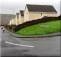
1
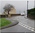
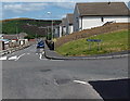
Bend in Rhiwgarn, Trebanog
Viewed from the corner of Cefn Bryn. The white van is approaching the Pen y Banc junction.
Image: © Jaggery
Taken: 16 Nov 2017
0.01 miles
2
Unnamed shop in Trebanog
On the corner of Rhiwgarn and Waun Wen.
Image: © Jaggery
Taken: 30 Jul 2014
0.02 miles
3
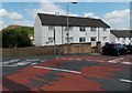
Pen y banc flats, Trebanog
Viewed across Rhiwgarn.
Image: © Jaggery
Taken: 30 Jul 2014
0.04 miles
4
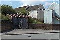
Rhiw Garn electricity substation, Trebanog
The identifier on the Western Power Distribution electricity substation inside an enclosure is
RHIW GARN TREBANOG S/S 542286.
Image: © Jaggery
Taken: 30 Jul 2014
0.04 miles
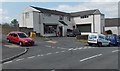
5
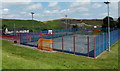
Multi-use sports court, Trebanog
Located west of the Waunwen Community Recreation Centre building. http://www.geograph.org.uk/photo/4096994
Several sports can be played here, monitored by CCTV cameras high up on poles.
Image: © Jaggery
Taken: 30 Jul 2014
0.05 miles
6
Cefn Bryn, Trebanog
Looking north from Rhiwgarn. Part of a black rectangular road repair patch is on the right.
Image: © Jaggery
Taken: 30 Jul 2014
0.05 miles
7
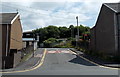
Western end of Rhiwgarn, Trebanog
Viewed across the A4233 Trebanog Road. Some maps name this road Rhiwgarn Road,
but the street name sign on the left http://www.geograph.org.uk/photo/5602501 shows only RHIWGARN.
The speed limit reduces from 30mph to 20mph a few metres ahead.
Image: © Jaggery
Taken: 30 Jul 2014
0.05 miles
8
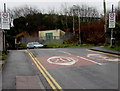
From 30 to 20 on Rhiwgarn, Trebanog
The 30mph speed limit on Trebanog Road drops to 20mph on the street named Rhiwgarn.
Image: © Jaggery
Taken: 16 Nov 2017
0.05 miles
9
North along Cefn Bryn, Trebanog
From the corner of Rhiwgarn.
Image: © Jaggery
Taken: 16 Nov 2017
0.06 miles
10
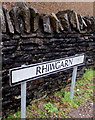
Welsh-only street name sign, Rhiwgarn, Trebanog
Near the Trebanog Road junction.
I didn't see any bilingual street name signs during a brief visit to Trebanog.
Some are English only, others Welsh only, as here.
Image: © Jaggery
Taken: 16 Nov 2017
0.06 miles