IMAGES TAKEN NEAR TO
Graigwen Road, PORTH, CF39 9HA
Introduction
This page details the photographs taken nearby to Graigwen Road, CF39 9HA by members of the Geograph project.
The Geograph project started in 2005 with the aim of publishing, organising and preserving representative images for every square kilometre of Great Britain, Ireland and the Isle of Man.

There are currently over 7.5m images from over14,400 individuals and you can help contribute to the project by visiting https://www.geograph.org.uk
Image Map
Images are licensed for reuse under creativecommons.org/licenses/by-sa/2.0
Notes
- Clicking on the map will re-center to the selected point.
- The higher the marker number, the further away the image location is from the centre of the postcode.
Image Listing (44 Images Found)
Images are licensed for reuse under creativecommons.org/licenses/by-sa/2.0
Image
Details
Distance
1
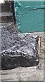
Ordnance Survey Rivet
This damaged OS rivet can be found on the sill of No65 High Street. It marks a point 128.677m above mean sea level.
Image: © Adrian Dust
Taken: 27 May 2018
0.05 miles
2
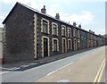
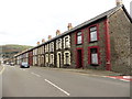
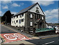
Long row of houses, High Street, Cymmer, Porth
Looking SSW from the corner of Catherine Crescent.
Image: © Jaggery
Taken: 30 Jul 2014
0.05 miles
4

Zebra crossing, High Street, Cymmer, Porth
Although Belisha beacons had marked pedestrian crossings in the UK from 1934, it was not until 1951 that the now familiar black and white stripes stretching across the width of the road were officially introduced. Previously, there were only metal studs across the road surface.
Image: © Jaggery
Taken: 30 Jul 2014
0.07 miles
5
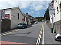
Catherine Crescent, Cymmer, Porth
Viewed from High Street. The edge of Rhondda Apostolic Mission http://www.geograph.org.uk/photo/4099992 is on the left.
Image: © Jaggery
Taken: 30 Jul 2014
0.07 miles
6
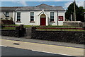
Rhondda Apostolic Mission, Cymmer, Porth
An Evangelical and Pentecostal church at 205 High Street, on the corner of Catherine Crescent.
Image: © Jaggery
Taken: 30 Jul 2014
0.07 miles
7

Ordnance Survey Cut Mark
This OS cut mark can be found on No46 High Street. It marks a point 123.008m above mean sea level.
Image: © Adrian Dust
Taken: 27 May 2018
0.08 miles
9
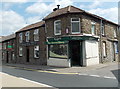
The Corner Shop and Cymmer Fish Bar, Cymmer, Porth
On the corner of High Street and Brook Street, The Corner Shop shows
the name W.R.G.Lewis over the doorway. Cymmer Fish Bar is on the left.
Image: © Jaggery
Taken: 30 Jul 2014
0.09 miles
10
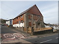
Flats in a converted former chapel in Cymmer, Porth
The building is on the corner of High Street and Catherine Crescent.
An inscription in Welsh on a wall shows that the building was erected in 1907
as Caersalem Newydd (New Jerusalem) chapel.
Image: © Jaggery
Taken: 30 Jul 2014
0.09 miles