
IMAGES TAKEN NEAR TO
Glan Ffrwd, PORTH, CF39 9EG
Introduction
This page details the photographs taken nearby to Glan Ffrwd, CF39 9EG by members of the Geograph project.
The Geograph project started in 2005 with the aim of publishing, organising and preserving representative images for every square kilometre of Great Britain, Ireland and the Isle of Man.

There are currently over 7.5m images from over14,400 individuals and you can help contribute to the project by visiting https://www.geograph.org.uk
Image Map
Images are licensed for reuse under creativecommons.org/licenses/by-sa/2.0
Notes
- Clicking on the map will re-center to the selected point.
- The higher the marker number, the further away the image location is from the centre of the postcode.
Image Listing (33 Images Found)
Images are licensed for reuse under creativecommons.org/licenses/by-sa/2.0
Image
Details
Distance
1
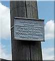
Byelaw notice issued by a now defunct council, Trebanog
Attached to a wooden pole http://www.geograph.org.uk/photo/4099756 alongside the A4233 Trebanog Road, the byelaw notice shows
RHONDDA B.C. (Borough Council). In 1974, the Borough of Rhondda was one of six local government districts of the new county of Mid Glamorgan. The borough was abolished in 1996, with its area passing to the unitary Rhondda Cynon Taf county borough.
Though the council no longer exists, is the stated penalty still applicable?
Image: © Jaggery
Taken: 30 Jul 2014
0.04 miles
2
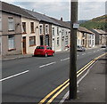
Houses near an old byelaw notice, Trebanog
Viewed across the A4233 Trebanog Road. http://www.geograph.org.uk/photo/4099744 to a closer view of the byelaw notice on the pole.
Image: © Jaggery
Taken: 30 Jul 2014
0.05 miles
3

Eastern end of Ton Hywel, Trebanog
This is one of two Ton Hywel/Trebanog Road junctions. The other one http://www.geograph.org.uk/photo/4099657 is about 350 metres away.
Image: © Jaggery
Taken: 30 Jul 2014
0.05 miles
4

Ordnance Survey Cut Mark
This OS cut mark can be found on No291 Trebanog Road. It marks a point 164.110m above mean sea level.
Image: © Adrian Dust
Taken: 27 May 2018
0.09 miles
5
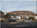
The Farmers Arms, Trebanog
Mynydd y Cymmer in the background.
Image: © John Lord
Taken: 1 Nov 2017
0.12 miles
7
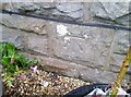
Ordnance Survey Cut Mark
This OS cut mark can be found on No49 Trebanog Road. It marks a point 195.386m above mean sea level.
Image: © Adrian Dust
Taken: 27 May 2018
0.12 miles
8
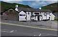
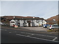
Farmers Arms, Trebanog
Pub on a flattish site at the side of a long steep gradient on the A4233 Trebanog Road.
Image: © Jaggery
Taken: 30 Jul 2014
0.13 miles
9

Thai Elephant Oriental Restaurant, Trebanog
On the corner of Trebanog Road and Heol Eurwen Davies, a few metres
on the Trebanog side of the Cymmer (Porth) boundary sign. http://www.geograph.org.uk/photo/4099798
Image: © Jaggery
Taken: 30 Jul 2014
0.13 miles
10
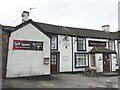
Farmers Arms, Trebanog
The Farmers Arms, Trebanog - a couple of miles outside Porth on the road to Tonyrefail.
Image: © Alan Hughes
Taken: 9 Mar 2017
0.13 miles