IMAGES TAKEN NEAR TO
Cymmer Road, PORTH, CF39 9BL
Introduction
This page details the photographs taken nearby to Cymmer Road, CF39 9BL by members of the Geograph project.
The Geograph project started in 2005 with the aim of publishing, organising and preserving representative images for every square kilometre of Great Britain, Ireland and the Isle of Man.

There are currently over 7.5m images from over14,400 individuals and you can help contribute to the project by visiting https://www.geograph.org.uk
Image Map
Images are licensed for reuse under creativecommons.org/licenses/by-sa/2.0
Notes
- Clicking on the map will re-center to the selected point.
- The higher the marker number, the further away the image location is from the centre of the postcode.
Image Listing (50 Images Found)
Images are licensed for reuse under creativecommons.org/licenses/by-sa/2.0
Image
Details
Distance
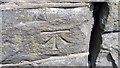
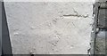
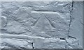
1
Ordnance Survey Cut Mark
This OS cut mark can be found on No20 Cymmer Road. It marks a point 100.261m above mean sea level.
Image: © Adrian Dust
Taken: 27 May 2018
0.07 miles
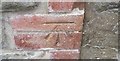
2
Ordnance Survey Cut Mark
This OS cut mark can be found on the wall north side of Cemetery Road. It marks a point 107.637m above mean sea level.
Image: © Adrian Dust
Taken: 24 Jun 2017
0.09 miles
3
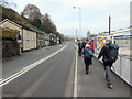
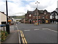
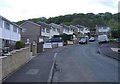
Heol y Cymer / Cymmer Road
Cerddwyr yn dilyn Heol y Cymer.
Walkers following Cymmer Road (trans. [river] confluence).
Image: © Alan Richards
Taken: 7 Apr 2019
0.10 miles
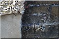
5
Ordnance Survey Cut Mark
The remains of this OS cut mark can be just about made out on No23 Cemetery Road. It marks a point 127.812m above mean sea level.
Image: © Adrian Dust
Taken: 24 Jun 2017
0.16 miles
6
Ordnance Survey Cut Mark
This OS cut mark can be found on No1 Penmain Street. It marks a point 138.273m above mean sea level.
Image: © Adrian Dust
Taken: 24 Jun 2017
0.19 miles
7
Ordnance Survey Cut Mark
This OS cut mark can be found on the garage of No2 Troedyrhiw Road. It marks a point 112.624m above mean sea level.
Image: © Adrian Dust
Taken: 24 Jun 2017
0.19 miles
8
Ordnance Survey Cut Mark
This OS cut mark can be found on the gatepost of No37 Troedyrhiw Road. It marks a point 118.319m above mean sea level.
Image: © Adrian Dust
Taken: 24 Jun 2017
0.19 miles