IMAGES TAKEN NEAR TO
Cefn Bryn, PORTH, CF39 9BJ
Introduction
This page details the photographs taken nearby to Cefn Bryn, CF39 9BJ by members of the Geograph project.
The Geograph project started in 2005 with the aim of publishing, organising and preserving representative images for every square kilometre of Great Britain, Ireland and the Isle of Man.

There are currently over 7.5m images from over14,400 individuals and you can help contribute to the project by visiting https://www.geograph.org.uk
Image Map
Images are licensed for reuse under creativecommons.org/licenses/by-sa/2.0
Notes
- Clicking on the map will re-center to the selected point.
- The higher the marker number, the further away the image location is from the centre of the postcode.
Image Listing (96 Images Found)
Images are licensed for reuse under creativecommons.org/licenses/by-sa/2.0
Image
Details
Distance
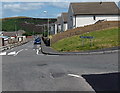
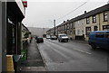
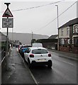
1

From 30 to 20 towards Cefn Bryn, Trebanog
The 30mph speed limit on the A4233 Trebanog Road drops to 20mph on the access road to Cefn Bryn.
Image: © Jaggery
Taken: 16 Nov 2017
0.01 miles
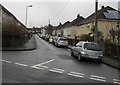
2
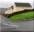
North along Cefn Bryn, Trebanog
From the corner of Rhiwgarn.
Image: © Jaggery
Taken: 16 Nov 2017
0.01 miles
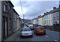
3
Cefn Bryn, Trebanog
Looking north from Rhiwgarn. Part of a black rectangular road repair patch is on the right.
Image: © Jaggery
Taken: 30 Jul 2014
0.03 miles
5
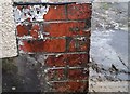
Ordnance Survey Cut Mark
This OS cut mark can be found on No91 Trebanog Road. It marks a point 230.295m above mean sea level.
Image: © Adrian Dust
Taken: 27 May 2018
0.03 miles
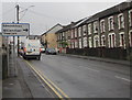
6
North along the A4233 Trebanog Road, Trebanog
Trebanog Stores http://www.geograph.org.uk/photo/5602494 are on the left.
Image: © Jaggery
Taken: 16 Nov 2017
0.03 miles
7
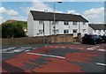
Pen y banc flats, Trebanog
Viewed across Rhiwgarn.
Image: © Jaggery
Taken: 30 Jul 2014
0.03 miles
8
Olive Terrace, Trebanog
From Trem-y-Glyn, Olive Terrace extends eastwards for 160 metres to the A4233 Trebanog Road.
Image: © Jaggery
Taken: 16 Nov 2017
0.04 miles
9
Direction sign, Trebanog Road, Trebanog
Facing southbound traffic on the A4233 Trebanog Road. Turn right ahead for Williamstown (Trewiliam in Welsh) and Edmondstown which doesn't appear to have a different name in Welsh.
Image: © Jaggery
Taken: 16 Nov 2017
0.04 miles
10
Low gear now/G?r isel nawr, Trebanog Road, Trebanog
The English/Welsh sign faces northbound traffic on the A4233 Trebanog Road on the approach to a 16% descent. 16% is between 1 in 6 and 1 in 7.
Image: © Jaggery
Taken: 16 Nov 2017
0.04 miles