1
Ffordd Llanbad houses in Hendreforgan
On the south side of the A4093.
Image: © Jaggery
Taken: 11 Apr 2014
0.04 miles
2
A4093/Ffordd Llanbad junction
Image: © Colin Pyle
Taken: 4 May 2012
0.05 miles
3
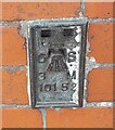
Ordnance Survey Flush Bracket (10152)
This OS Flush Bracket can be found on the NW face of the school. It marks a point 216.334m above mean sea level.
Image: © Adrian Dust
Taken: 17 May 2022
0.06 miles
4
Ordnance Survey Cut Mark
This OS cut mark can be found on the gatepost of the school. It marks a point 216.413m above mean sea level.
Image: © Adrian Dust
Taken: 17 May 2022
0.07 miles
5
Ffordd Llanbad, Hendreforgan
Ffordd Llanbad descends from the A4093 towards the valley of a stream, Nant Erin.
There are many wind turbines on the hills in the background.
Image: © Jaggery
Taken: 11 Apr 2014
0.08 miles
6
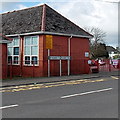
Hendreforgan Community Primary School, Gilfach Goch
Viewed across the A4093. Hendreforgan is part of Gilfach Goch.
Image: © Jaggery
Taken: 11 Apr 2014
0.08 miles
7
Distances from Hendreforgan, Gilfach Goch
The signs are alongside the A4093 at the edge of Hendreforgan Community Primary School http://www.geograph.org.uk/photo/3926243 facing the B4564 Cambrian Avenue junction. Left for Tonyrefail (1½ (miles)), right for Blackmill (3½).
Image: © Jaggery
Taken: 11 Apr 2014
0.09 miles
8
Alternating roof colours, Heol y Mynydd, Hendreforgan
Viewed across the A4093. This pattern is not repeated on the roofs of neighbouring semi-detached houses.
Image: © Jaggery
Taken: 11 Apr 2014
0.10 miles
9
The road to Gilfach Goch
The tower is at the fire station shown in
Image
Image: © Nick Smith
Taken: 24 Apr 2011
0.11 miles
10
Gilfach Goch Fire Station
Gilfach Goch Fire Station, Hendreforgan, Gilfach Goch - part of South Wales Fire & Rescue Service
Image: © Kevin Hale
Taken: 5 Jun 2007
0.12 miles


