IMAGES TAKEN NEAR TO
Brynhyfryd, PORTH, CF39 8UN
Introduction
This page details the photographs taken nearby to Brynhyfryd, CF39 8UN by members of the Geograph project.
The Geograph project started in 2005 with the aim of publishing, organising and preserving representative images for every square kilometre of Great Britain, Ireland and the Isle of Man.

There are currently over 7.5m images from over14,400 individuals and you can help contribute to the project by visiting https://www.geograph.org.uk
Image Map
Images are licensed for reuse under creativecommons.org/licenses/by-sa/2.0
Notes
- Clicking on the map will re-center to the selected point.
- The higher the marker number, the further away the image location is from the centre of the postcode.
Image Listing (27 Images Found)
Images are licensed for reuse under creativecommons.org/licenses/by-sa/2.0
Image
Details
Distance
1
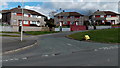
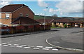
Alternating roof colours, Heol y Mynydd, Hendreforgan
Viewed across the A4093. This pattern is not repeated on the roofs of neighbouring semi-detached houses.
Image: © Jaggery
Taken: 11 Apr 2014
0.05 miles
3
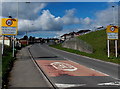
Welcome to Gilfach Goch
The A4093 reaches the welcome sign at the eastern edge of the village. The surrounding area is partly in the county borough of Rhondda Cynon Taf, partly in the county borough of Bridgend.
The 40mph speed limit reduces to 30mph.
Image: © Jaggery
Taken: 11 Apr 2014
0.09 miles
4
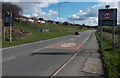
Start of the 40mph speed limit east of Gilfach Goch
The 30mph speed limit through the village increases to 40mph beyond the grey backs of the Gilfach Goch welcome signs. http://www.geograph.org.uk/photo/3926193
Image: © Jaggery
Taken: 11 Apr 2014
0.11 miles
5
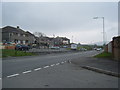
Ffordd Llanbad houses in Hendreforgan
On the south side of the A4093.
Image: © Jaggery
Taken: 11 Apr 2014
0.11 miles
6
Ffordd Llanbad, Hendreforgan
Ffordd Llanbad descends from the A4093 towards the valley of a stream, Nant Erin.
There are many wind turbines on the hills in the background.
Image: © Jaggery
Taken: 11 Apr 2014
0.13 miles
7
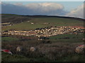
Distant view of Hendreforgan
With Mynydd y Gilfach behind
Image: © John Finch
Taken: 5 Dec 2011
0.14 miles
8
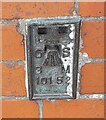
Ordnance Survey Flush Bracket (10152)
This OS Flush Bracket can be found on the NW face of the school. It marks a point 216.334m above mean sea level.
Image: © Adrian Dust
Taken: 17 May 2022
0.14 miles
9
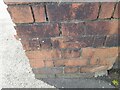
Ordnance Survey Cut Mark
This OS cut mark can be found on the gatepost of the school. It marks a point 216.413m above mean sea level.
Image: © Adrian Dust
Taken: 17 May 2022
0.15 miles
10
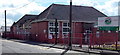
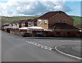
Hendreforgan Community Primary School, Gilfach Goch
Viewed across the A4093. Hendreforgan is part of Gilfach Goch.
Image: © Jaggery
Taken: 11 Apr 2014
0.16 miles