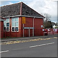
1
Hendreforgan Crescent, Gilfach Goch
On the south side of the A4093.
Image: © Jaggery
Taken: 11 Apr 2014
0.02 miles
2
JAG-Saracen, Hendreforgan, Gilfach Goch
Located next door to Gilfach Goch fire station, http://www.geograph.org.uk/photo/3926226 JAG-Saracen supplies conservatories, replacement windows and secondary double glazing, various types of doors etc.
Image: © Jaggery
Taken: 11 Apr 2014
0.06 miles
3
SW boundary of Gilfach Goch
The A4093 from Blackmill reaches Gilfach Goch, a former coal mining village in the County Borough of Rhondda Cynon Taf. Some of the adjacent area is in the County Borough of Bridgend.
Image: © Jaggery
Taken: 11 Apr 2014
0.06 miles
4
Gilfach Goch fire station
Part of the South Wales Fire and Rescue Service, Gilfach Goch fire station
is on the corner of the A4093 and the B4564 Cambrian Avenue in Hendreforgan.
Image: © Jaggery
Taken: 11 Apr 2014
0.07 miles
5
The road to Gilfach Goch
The tower is at the fire station shown in
Image
Image: © Nick Smith
Taken: 24 Apr 2011
0.07 miles
6
Gilfach Goch Fire Station
Gilfach Goch Fire Station, Hendreforgan, Gilfach Goch - part of South Wales Fire & Rescue Service
Image: © Kevin Hale
Taken: 5 Jun 2007
0.08 miles
7
Gilfach Goch fire station tower
On the corner of the A4093 and the B4564 Cambrian Avenue in Hendreforgan.
http://www.geograph.org.uk/photo/3926226 to a view of the A4093 side of the fire station.
Image: © Jaggery
Taken: 11 Apr 2014
0.08 miles
8
Distances from Hendreforgan, Gilfach Goch
The signs are alongside the A4093 at the edge of Hendreforgan Community Primary School http://www.geograph.org.uk/photo/3926243 facing the B4564 Cambrian Avenue junction. Left for Tonyrefail (1½ (miles)), right for Blackmill (3½).
Image: © Jaggery
Taken: 11 Apr 2014
0.09 miles
9
Recently-built house near Hendreforgan Farm, Gilfach Goch
Viewed across the A4093 in April 2014. The house on the right does not appear in a Google Earth Street View taken in September 2009.
Image: © Jaggery
Taken: 11 Apr 2014
0.09 miles
10
Hendreforgan Community Primary School, Gilfach Goch
Viewed across the A4093. Hendreforgan is part of Gilfach Goch.
Image: © Jaggery
Taken: 11 Apr 2014
0.09 miles


