IMAGES TAKEN NEAR TO
Evanstown, Gilfach Goch, PORTH, CF39 8RG
Introduction
This page details the photographs taken nearby to CF39 8RG by members of the Geograph project.
The Geograph project started in 2005 with the aim of publishing, organising and preserving representative images for every square kilometre of Great Britain, Ireland and the Isle of Man.

There are currently over 7.5m images from over14,400 individuals and you can help contribute to the project by visiting https://www.geograph.org.uk
Image Map
Images are licensed for reuse under creativecommons.org/licenses/by-sa/2.0
Notes
- Clicking on the map will re-center to the selected point.
- The higher the marker number, the further away the image location is from the centre of the postcode.
Image Listing (81 Images Found)
Images are licensed for reuse under creativecommons.org/licenses/by-sa/2.0
Image
Details
Distance
1
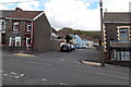
Dan-y-bryn, Evanstown
Viewed across Coronation Road.
Image: © Jaggery
Taken: 11 Apr 2014
0.05 miles
2
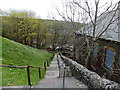
Steps down from Abercerdin Road, Evanstown
The former Calfaria Baptist Chapel http://www.geograph.org.uk/photo/4075596 is on the right.
Image: © Jaggery
Taken: 11 Apr 2014
0.05 miles
3
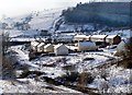
A walk in the snow - Danybryn, Gilfach Goch
A photo that I took while out walking.
Image: © Wyndham Jones
Taken: 5 Feb 2009
0.06 miles
4
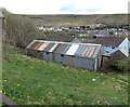
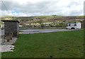
Multi-coloured metal roof, Evanstown
The 20 metre long corrugated metal building is set below the B4564 Abercerdin Road.
Image: © Jaggery
Taken: 11 Apr 2014
0.06 miles
5
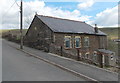
Former Calfaria Baptist Chapel, Evanstown
The Abercerdin Road building is now in residential use. The inscription in Welsh on the wall
shows that it was built in 1897 as Calfaria Baptist Chapel. Calfaria is Welsh for Calvary.
Image: © Jaggery
Taken: 11 Apr 2014
0.07 miles
6
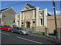
Evanstown Community Centre
Facade of Evanstown Community Centre...what was it originally?
Image: © Colin Pyle
Taken: 22 Aug 2008
0.07 miles
7
Three-axled kebab van in Evanstown
In a corner of a parking area alongside the B4564 Abercerdin Road.
Image: © Jaggery
Taken: 11 Apr 2014
0.07 miles
8
Ordnance Survey Pivot
This OS pivot can be found on the wall of No26 Coronation Road. It marks a point 214.015m above mean sea level.
Image: © Adrian Dust
Taken: 1 Nov 2016
0.07 miles
9
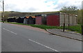
Lockup garages, Evanstown
Alongside the B4564 Abercerdin Road, opposite Adare Street. http://www.geograph.org.uk/photo/4075575
Image: © Jaggery
Taken: 11 Apr 2014
0.07 miles
10

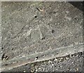
Ordnance Survey Rivet
This OS cut mark can be found on the wall of the steps SE side of Abercerdin Road. It marks a point 237.339m above mean sea level.
Image: © Adrian Dust
Taken: 17 May 2022
0.08 miles