IMAGES TAKEN NEAR TO
Ffordd Maendy, CF39 8QF
Introduction
This page details the photographs taken nearby to Ffordd Maendy, CF39 8QF by members of the Geograph project.
The Geograph project started in 2005 with the aim of publishing, organising and preserving representative images for every square kilometre of Great Britain, Ireland and the Isle of Man.

There are currently over 7.5m images from over14,400 individuals and you can help contribute to the project by visiting https://www.geograph.org.uk
Image Map
Images are licensed for reuse under creativecommons.org/licenses/by-sa/2.0
Notes
- Clicking on the map will re-center to the selected point.
- The higher the marker number, the further away the image location is from the centre of the postcode.
Image Listing (7 Images Found)
Images are licensed for reuse under creativecommons.org/licenses/by-sa/2.0
Image
Details
Distance
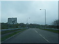
1
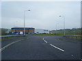
Roundabout, from new road not on the map
This road is shown on my new OS map of the area as a path... it still has raised iron-work, it's that new.
Image: © Ruth Sharville
Taken: 23 Jun 2007
0.12 miles
2
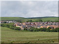
Housing estate
Look at the map and you'd think I took this from a path. Not so! There is a new road there now, part way along which is a factory. Just proves how difficult it is to have an "up-to-date" map...
Image: © Ruth Sharville
Taken: 23 Jun 2007
0.16 miles
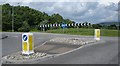
3
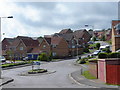
Mini-roundabout and housing estate
This estate, like a few others we've seen in the Valleys, is called Mountain View
Image: © Ruth Sharville
Taken: 23 Jun 2007
0.21 miles
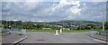
5
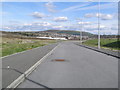
View of Tonyrefail from a new factory access road
This long distance view of Tonyrefail is from a new factory access road built to link with the A4093 at a nearby roundabout.
Image: © Brian Green
Taken: 19 Mar 2008
0.21 miles