IMAGES TAKEN NEAR TO
Primrose Court, PORTH, CF39 8NB
Introduction
This page details the photographs taken nearby to Primrose Court, CF39 8NB by members of the Geograph project.
The Geograph project started in 2005 with the aim of publishing, organising and preserving representative images for every square kilometre of Great Britain, Ireland and the Isle of Man.

There are currently over 7.5m images from over14,400 individuals and you can help contribute to the project by visiting https://www.geograph.org.uk
Image Map
Images are licensed for reuse under creativecommons.org/licenses/by-sa/2.0
Notes
- Clicking on the map will re-center to the selected point.
- The higher the marker number, the further away the image location is from the centre of the postcode.
Image Listing (13 Images Found)
Images are licensed for reuse under creativecommons.org/licenses/by-sa/2.0
Image
Details
Distance
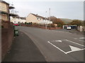
3
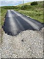
End of the road?
I think they ran out of tarmac!
Image: © Alan Hughes
Taken: 10 Jul 2020
0.17 miles
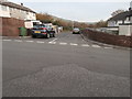
4
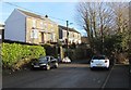
Houses above the eastern end of High Street, Tonyrefail
This is a dead end for motor vehicles. Walkers and cyclists can use the path ahead to reach Llantrisant Road.
Image: © Jaggery
Taken: 10 Jan 2018
0.18 miles
5
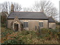
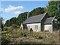
The former Church of St John the Baptist
Now no longer used as a church, having been replaced by St David's when the growing population of Tonyrefail meant it was too small. It subsequently became the HQ of the local Scout troop.
Image: © John Lord
Taken: 1 Nov 2017
0.18 miles
6
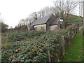
Overgrown graveyard and the former Church of St John the Baptist
Image: © John Lord
Taken: 1 Nov 2017
0.18 miles
7
Abandoned and neglected church at Tonyrefail
A noticeboard proclaims this to be the meeting place of a local scout troop though I think that they might well have abandoned it too.
Image: © Mick Lobb
Taken: 19 Sep 2008
0.20 miles
8
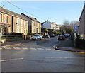
Eastern end of High Street, Tonyrefail
Viewed from the Pretoria Road junction. High Street ahead is a dead end
for motor vehicles, though a sign on the right shows a cycle route ahead.
Image: © Jaggery
Taken: 10 Jan 2018
0.21 miles