IMAGES TAKEN NEAR TO
Heol Aneurin, PORTH, CF39 8LN
Introduction
This page details the photographs taken nearby to Heol Aneurin, CF39 8LN by members of the Geograph project.
The Geograph project started in 2005 with the aim of publishing, organising and preserving representative images for every square kilometre of Great Britain, Ireland and the Isle of Man.

There are currently over 7.5m images from over14,400 individuals and you can help contribute to the project by visiting https://www.geograph.org.uk
Image Map
Images are licensed for reuse under creativecommons.org/licenses/by-sa/2.0
Notes
- Clicking on the map will re-center to the selected point.
- The higher the marker number, the further away the image location is from the centre of the postcode.
Image Listing (27 Images Found)
Images are licensed for reuse under creativecommons.org/licenses/by-sa/2.0
Image
Details
Distance
1
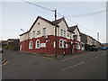
Red Gate Close, Tonyrefail
On the north side of High Street. The Red Gate pub https://www.geograph.org.uk/photo/5649293 is on the right.
Image: © Jaggery
Taken: 10 Jan 2018
0.09 miles
2
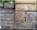
Ordnance Survey Cut Mark
This OS cut mark can be found on No133 High Street. It marks a point 161.892m above mean sea level.
Image: © Adrian Dust
Taken: 27 May 2018
0.10 miles
3
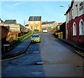
Junction of High Street and Pretoria Road, Tonyrefail
Viewed from the dead-end eastern part of High Street.
The through part of High Street is ahead. Pretoria Road is on the left.
Image: © Jaggery
Taken: 10 Jan 2018
0.11 miles
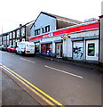
4
Gwalia Auto Factors, 110 High Street, Tonyrefail
The shop on the corner of The Avenue sells vehicle parts and accessories.
Image: © Jaggery
Taken: 10 Jan 2018
0.11 miles
5
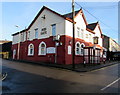
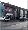
Red Gate in Tonyrefail
High Street pub on the corner of Red Gate Close. https://www.geograph.org.uk/photo/5649317 to the pub sign.
Image: © Jaggery
Taken: 10 Jan 2018
0.11 miles
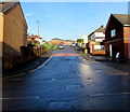
6
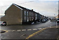
West along High Street, Tonyrefail
Towards the Pretoria Road junction. This is the residential part of High Street - shops are out of shot ahead.
Image: © Jaggery
Taken: 10 Jan 2018
0.11 miles
8
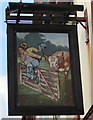
Red Gate sign, Tonyrefail
Hanging from a wall bracket here. https://www.geograph.org.uk/photo/5649293
Image: © Jaggery
Taken: 10 Jan 2018
0.12 miles
10
St John's Road, Tonyrefail
Ascending from the north side of High Street. The 30mph speed limit drops to 20 on the approach to a school.
Image: © Jaggery
Taken: 10 Jan 2018
0.12 miles