IMAGES TAKEN NEAR TO
Cae'r Gwerlas, PORTH, CF39 8HY
Introduction
This page details the photographs taken nearby to Cae'r Gwerlas, CF39 8HY by members of the Geograph project.
The Geograph project started in 2005 with the aim of publishing, organising and preserving representative images for every square kilometre of Great Britain, Ireland and the Isle of Man.

There are currently over 7.5m images from over14,400 individuals and you can help contribute to the project by visiting https://www.geograph.org.uk
Image Map
Images are licensed for reuse under creativecommons.org/licenses/by-sa/2.0
Notes
- Clicking on the map will re-center to the selected point.
- The higher the marker number, the further away the image location is from the centre of the postcode.
Image Listing (17 Images Found)
Images are licensed for reuse under creativecommons.org/licenses/by-sa/2.0
Image
Details
Distance
1
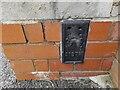
Ordnance Survey Flush Bracket (S1372)
This OS Flush Bracket can be found on a west face on the north side of the school. It marks a point 139.449m above mean sea level.
Image: © Adrian Dust
Taken: 17 May 2022
0.14 miles
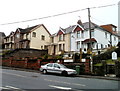
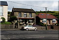
2
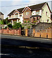
Houses above Gilfach Road, Tonyrefail
On the right here. http://www.geograph.org.uk/photo/5509778
Image: © Jaggery
Taken: 24 Aug 2017
0.14 miles
3
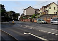
Up Gilfach Road, Tonyrefail
The B4278 Gilfach Road climbs past the left turn into Tynybryn Road.
Image: © Jaggery
Taken: 24 Aug 2017
0.14 miles
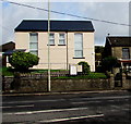
4
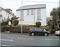
Salem English Baptist Chapel, Tonyrefail
Chapel dating from 1905 located on Gilfach Road, opposite Tynybryn Road. The 'English' in its name denotes the language used for worship, to distinguish it from chapels where services were conducted in Welsh.
Image: © Jaggery
Taken: 9 Feb 2011
0.14 miles
5
Tonyrefail : Gilfach Road houses facing Tynybryn Road
The houses are adjacent to Salem English Baptist Chapel http://www.geograph.org.uk/photo/2264319 on the right edge of the view.
Image: © Jaggery
Taken: 9 Feb 2011
0.14 miles
6
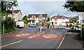
Junction of Tynybryn Road and Gilfach Road, Tonyrefail
The 20mph speed limit on Tynybryn Road increases to 30mph on the approach to the B4278 Gilfach Road.
Image: © Jaggery
Taken: 24 Aug 2017
0.15 miles
7
Salem English Baptist Chapel, Gilfach Road, Tonyrefail
The chapel dates from 1905. The English in its name denotes the language used for worship,
to distinguish it from chapels where services are (or were) conducted in Welsh.
Image: © Jaggery
Taken: 24 Aug 2017
0.15 miles
8
Thomastown direction and distance sign, Gilfach Road, Tonyrefail
Turn left into Tynybryn Road for Thomastown three-quarters of a mile away.
Image: © Jaggery
Taken: 24 Aug 2017
0.15 miles
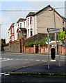
9
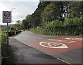
Start of the 20 zone at the northern end of Tynybryn Road, Tonyrefail
The 30mph speed limit on the B4278 Gilfach Road drops to 20mph on Tynybryn Road.
PARTH is Welsh for ZONE.
Image: © Jaggery
Taken: 24 Aug 2017
0.16 miles
10
Gilfach Road houses, Tonyrefail
Viewed across the B4278 Gilfach Road. The edge of Salem English Baptist Chapel http://www.geograph.org.uk/photo/5509744 is on the left.
Image: © Jaggery
Taken: 24 Aug 2017
0.16 miles