IMAGES TAKEN NEAR TO
/Pantybrad, PORTH, CF39 8HX
Introduction
This page details the photographs taken nearby to /Pantybrad, CF39 8HX by members of the Geograph project.
The Geograph project started in 2005 with the aim of publishing, organising and preserving representative images for every square kilometre of Great Britain, Ireland and the Isle of Man.

There are currently over 7.5m images from over14,400 individuals and you can help contribute to the project by visiting https://www.geograph.org.uk
Image Map
Images are licensed for reuse under creativecommons.org/licenses/by-sa/2.0
Notes
- Clicking on the map will re-center to the selected point.
- The higher the marker number, the further away the image location is from the centre of the postcode.
Image Listing (13 Images Found)
Images are licensed for reuse under creativecommons.org/licenses/by-sa/2.0
Image
Details
Distance
2
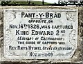
Pant y Brad plaque
Plaque located on the old road between Tonyrefail and Llantrisant. It records an important moment in medieval history when King Edward II was captured by supporters of the forces of Isabella and Mortimer in 1326. What happened subsequently to Edward is the subject of some lurid story-telling.
Image: © Alan Hughes
Taken: 10 Jul 2020
0.05 miles

5
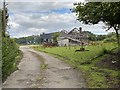
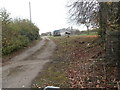
Ruined building
Ruined farm building at Oaklands Farm.
Image: © Alan Hughes
Taken: 10 Jul 2020
0.08 miles
7
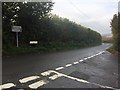
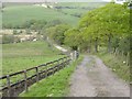
Road Junction
Road junction at Pont y Brad, with Llantrisant to the left and Tonyrefail to the right.
Image: © Alan Hughes
Taken: 5 Nov 2018
0.19 miles