IMAGES TAKEN NEAR TO
Gilfach Road, PORTH, CF39 8HL
Introduction
This page details the photographs taken nearby to Gilfach Road, CF39 8HL by members of the Geograph project.
The Geograph project started in 2005 with the aim of publishing, organising and preserving representative images for every square kilometre of Great Britain, Ireland and the Isle of Man.

There are currently over 7.5m images from over14,400 individuals and you can help contribute to the project by visiting https://www.geograph.org.uk
Image Map
Images are licensed for reuse under creativecommons.org/licenses/by-sa/2.0
Notes
- Clicking on the map will re-center to the selected point.
- The higher the marker number, the further away the image location is from the centre of the postcode.
Image Listing (13 Images Found)
Images are licensed for reuse under creativecommons.org/licenses/by-sa/2.0
Image
Details
Distance
1
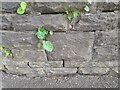
Ordnance Survey Cut Mark
This OS cut mark can be found on the cemetery wall NE side of Gilfach Road. It marks a point 149.709m above mean sea level.
Image: © Adrian Dust
Taken: 17 May 2022
0.02 miles
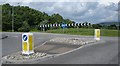
2
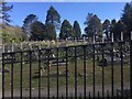
Bryn Golau Cemetery
Cemetery near Tonyrefail.
Image: © Alan Hughes
Taken: 11 Apr 2019
0.04 miles
3

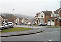
Corner of Dan-y-fron and Gilfach Road, Tonyrefail
Modern houses viewed across Gilfach Road (B4278).
Image: © Jaggery
Taken: 9 Feb 2011
0.04 miles
4
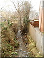
Small stream flows away from Gilfach Road, Tonyrefail
An unnamed stream flows between houses on Dan-y-fron on the right, and the edge of Padfield Court Business Park. The stream empties into Nant Erin, about 250 metres away.
Image: © Jaggery
Taken: 9 Feb 2011
0.04 miles
5
Dan-y-fron, Tonyrefail
Viewed from the Gilfach Road end. The houses were built in the first decade of the 21st century.
Image: © Jaggery
Taken: 9 Feb 2011
0.05 miles
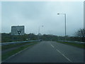
6

Northern edge of Padfield Court Business Park, Tonyrefail
Viewed across Gilfach Road. Businesses in view include Rhondda Skip Hire, Ton Tyres & Car Wash and The Magic Sponge vehicle valeting service.
Image: © Jaggery
Taken: 9 Feb 2011
0.09 miles
7

House and bungalows, Gilfach Road, Tonyrefail
Located on the south side of Gilfach Road (B4278), facing houses on Bryngolau.
Image: © Jaggery
Taken: 9 Feb 2011
0.15 miles
10
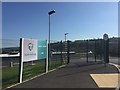
Tonyrefail School
Entrance to Tonyrefail Community School.
Image: © Alan Hughes
Taken: 11 Apr 2019
0.20 miles