IMAGES TAKEN NEAR TO
Highfields, PORTH, CF39 8GA
Introduction
This page details the photographs taken nearby to Highfields, CF39 8GA by members of the Geograph project.
The Geograph project started in 2005 with the aim of publishing, organising and preserving representative images for every square kilometre of Great Britain, Ireland and the Isle of Man.

There are currently over 7.5m images from over14,400 individuals and you can help contribute to the project by visiting https://www.geograph.org.uk
Image Map
Images are licensed for reuse under creativecommons.org/licenses/by-sa/2.0
Notes
- Clicking on the map will re-center to the selected point.
- The higher the marker number, the further away the image location is from the centre of the postcode.
Image Listing (5 Images Found)
Images are licensed for reuse under creativecommons.org/licenses/by-sa/2.0
Image
Details
Distance
3
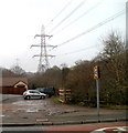
Pylons convey power lines above Bird's premises, Coed Ely
Power lines cross above Bird's premises http://www.geograph.org.uk/photo/2264730 (on the far side of the hedge) , and Ely Valley Road.
Image: © Jaggery
Taken: 9 Feb 2011
0.20 miles
4
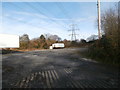
Power line pylon, Ely Valley Rd, Tonyrefail
Image: © John Lord
Taken: 17 Nov 2017
0.21 miles
5
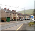
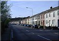
1-18 Nant Melyn Terrace, Tonyrefail
A row of 18 houses on the NE side of Ely Valley Road, extending from the perimeter of Coedely Constitutional Club http://www.geograph.org.uk/photo/2264688 (behind the camera) to the corner of Gwern Heulog. Nant Melyn Terrace continues http://www.geograph.org.uk/photo/2264722 on the far side of Gwern Heulog
Image: © Jaggery
Taken: 9 Feb 2011
0.22 miles