IMAGES TAKEN NEAR TO
Parc Coed-Elai, PORTH, CF39 8FR
Introduction
This page details the photographs taken nearby to Parc Coed-Elai, CF39 8FR by members of the Geograph project.
The Geograph project started in 2005 with the aim of publishing, organising and preserving representative images for every square kilometre of Great Britain, Ireland and the Isle of Man.

There are currently over 7.5m images from over14,400 individuals and you can help contribute to the project by visiting https://www.geograph.org.uk
Image Map
Images are licensed for reuse under creativecommons.org/licenses/by-sa/2.0
Notes
- Clicking on the map will re-center to the selected point.
- The higher the marker number, the further away the image location is from the centre of the postcode.
Image Listing (14 Images Found)
Images are licensed for reuse under creativecommons.org/licenses/by-sa/2.0
Image
Details
Distance
2
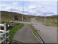
Parc Coed-Elai access road
This short piece of tarmac access road, complete with lighting, is not currently in use as a large bolted metal gate prevents vehicules from entering.
Image: © Brian Green
Taken: 19 Mar 2008
0.14 miles
3
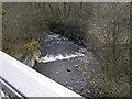
Weir on Nant Muchudd
This view is from the modern metal bridge over the river, looking south.
Image: © Brian Green
Taken: 19 Mar 2008
0.18 miles
4
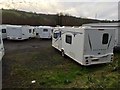
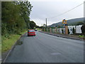
Commercial Caravan Site
Stowford Caravans, Coedely.
Image: © Alan Hughes
Taken: 9 Mar 2017
0.20 miles
5
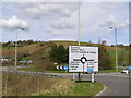
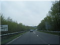
Coedley roundabout
Roundabout on the A4119.
Image: © Brian Green
Taken: 19 Mar 2008
0.20 miles
6
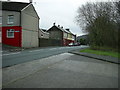
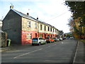
Elwyn Street, Coedely
Elwyn Street is the main unclassified road through Coedely.
Image: © Martyn Harries
Taken: 12 Dec 2011
0.20 miles
8
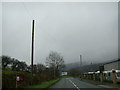
Bend in the road, Coedely
Bend in the road from Coedely approaching the A4119 roundabout.
Image: © Martyn Harries
Taken: 21 Nov 2011
0.20 miles
10
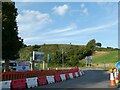
Roadworks on A4119 at roundabout near Coedely
Image: © David Smith
Taken: 21 Sep 2022
0.21 miles