1
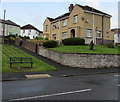
Houses above Tynybryn Road, Tonyrefail
The walker is ascending the path to the road named Heol Ton.
Image: © Jaggery
Taken: 24 Aug 2017
0.05 miles
2
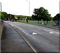
Junction of Tynybryn Road and Heol Ton, Tonyrefail
The 20mph speed limit on Tynybryn Road increases to 30mph on Heol Ton ahead.
Image: © Jaggery
Taken: 24 Aug 2017
0.06 miles
3
Morgan Sindall construction site, Tonyrefail
Above Tynybryn Road at the eastern edge of the Tonyrefail Comprehensive School site viewed in August 2017.
Image: © Jaggery
Taken: 24 Aug 2017
0.06 miles
4
Tynybryn Road speeds bumps, Tonyrefail
A children's playground http://www.geograph.org.uk/photo/5514402 is on the right.
Image: © Jaggery
Taken: 24 Aug 2017
0.08 miles
5
Tynybryn Park path junction, Tonyrefail
In the southeast corner of the park, viewed from Tynybryn Road.
Image: © Jaggery
Taken: 24 Aug 2017
0.08 miles
6
Park entrance path, Tonyrefail
Descending from Tynybryn Road into the west side of Tynybryn Park.
Image: © Jaggery
Taken: 24 Aug 2017
0.08 miles
7
Tonyrefail & District Community Council information board, Tonyrefail
In the southeast corner of Tynybryn Park, facing Tynybryn Road
Image: © Jaggery
Taken: 24 Aug 2017
0.09 miles
8
Tynybryn Road bus stop, Tonyrefail
This stop near the northern end of Tynybryn Road is for buses to Tonypandy.
Image: © Jaggery
Taken: 24 Aug 2017
0.10 miles
9
Tynybryn Park children's play area, Tonyrefail
In the southeast corner of the park, viewed from Tynybryn Road.
Image: © Jaggery
Taken: 24 Aug 2017
0.10 miles
10
Ordnance Survey Flush Bracket (S1372)
This OS Flush Bracket can be found on a west face on the north side of the school. It marks a point 139.449m above mean sea level.
Image: © Adrian Dust
Taken: 17 May 2022
0.11 miles


