IMAGES TAKEN NEAR TO
Heol Brynteg, PORTH, CF39 8DL
Introduction
This page details the photographs taken nearby to Heol Brynteg, CF39 8DL by members of the Geograph project.
The Geograph project started in 2005 with the aim of publishing, organising and preserving representative images for every square kilometre of Great Britain, Ireland and the Isle of Man.

There are currently over 7.5m images from over14,400 individuals and you can help contribute to the project by visiting https://www.geograph.org.uk
Image Map
Images are licensed for reuse under creativecommons.org/licenses/by-sa/2.0
Notes
- Clicking on the map will re-center to the selected point.
- The higher the marker number, the further away the image location is from the centre of the postcode.
Image Listing (52 Images Found)
Images are licensed for reuse under creativecommons.org/licenses/by-sa/2.0
Image
Details
Distance
1
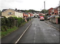
West along Heol Pymmer, Tonyrefail
From the corner of Tynybryn Road.
Image: © Jaggery
Taken: 24 Aug 2017
0.04 miles
2
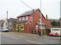
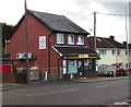
Tyn-y-Bryn Stores, Tonyrefail
Formerly post office http://www.geograph.org.uk/photo/695777 and store, now only store.
Image: © Jaggery
Taken: 9 Feb 2011
0.05 miles
3
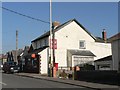
Tonyrefail: Tynybryn Post Office
This office will close permanently on 27 February 2008.
Image: © Chris Downer
Taken: 18 Feb 2008
0.07 miles
4
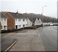
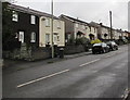
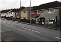
Houses on a bend in Tynybryn Road, Tonyrefail
A variety of house types occupy this section of Tynybryn Road, just south of a recreation ground.
Image: © Jaggery
Taken: 9 Feb 2011
0.07 miles
5
Nisa Local, Tynybryn Road, Tonyrefail
Viewed from the corner of Heol Pymmer.
Image: © Jaggery
Taken: 24 Aug 2017
0.07 miles
6
Tynybryn Road houses, Tonyrefail
On the west side of Tynybryn Road.
Image: © Jaggery
Taken: 24 Aug 2017
0.08 miles
7
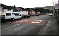
End of the 20 zone, Tynybryn Road, Tonyrefail
The 20mph speed limit increases to 30mph.
Image: © Jaggery
Taken: 24 Aug 2017
0.08 miles
8
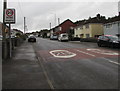
Start of the 20 zone, Tynybryn Road, Tonyrefail
The 30mph speed limit drops to 20mph. PARTH is Welsh for ZONE.
Image: © Jaggery
Taken: 24 Aug 2017
0.08 miles
9
Tynybryn Road semis, Tonyrefail
Semi-detached houses on the east side of Tynybryn Road.
Image: © Jaggery
Taken: 24 Aug 2017
0.08 miles
10

Warning sign Patrol/Hebryngwr, Tonyrefail
The English/Welsh sign faces northbound traffic on Tynybryn Road.
Image: © Jaggery
Taken: 24 Aug 2017
0.09 miles