IMAGES TAKEN NEAR TO
Pleasant View, PORTH, CF39 0PN
Introduction
This page details the photographs taken nearby to Pleasant View, CF39 0PN by members of the Geograph project.
The Geograph project started in 2005 with the aim of publishing, organising and preserving representative images for every square kilometre of Great Britain, Ireland and the Isle of Man.

There are currently over 7.5m images from over14,400 individuals and you can help contribute to the project by visiting https://www.geograph.org.uk
Image Map
Images are licensed for reuse under creativecommons.org/licenses/by-sa/2.0
Notes
- Clicking on the map will re-center to the selected point.
- The higher the marker number, the further away the image location is from the centre of the postcode.
Image Listing (47 Images Found)
Images are licensed for reuse under creativecommons.org/licenses/by-sa/2.0
Image
Details
Distance
1
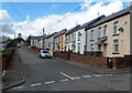
Western end of Heol Llechau, Wattstown
Looking WSW from the corner of Heol Goronwy.
Image: © Jaggery
Taken: 19 Sep 2012
0.03 miles
3
Western section of Heol-y-twyn, Wattstown
Looking south along Heol-y-twyn from the edge of a children's playground. http://www.geograph.org.uk/photo/3586980
Image: © Jaggery
Taken: 19 Sep 2012
0.09 miles
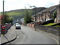
4
Towards Hillside Terrace, Wattstown
Viewed from near the Aberllechau Road junction, http://www.geograph.org.uk/photo/3586531 an unnamed road ascends
towards Hillside Terrace and the main residential area of Wattstown.
Image: © Jaggery
Taken: 19 Sep 2012
0.10 miles
5
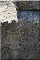
Ordnance Survey Rivet
This OS Rivet can be found on the wall at the junction of Cefn Road & Pleasant View. It marks a point 191.088m above mean sea level.
Image: © Adrian Dust
Taken: 18 Jun 2017
0.10 miles
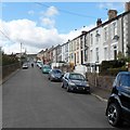
6
Heol Ceiriog, Wattstown
Houses on the north side of Heol Ceiriog viewed from the corner of Heol Goronwy.
Image: © Jaggery
Taken: 19 Sep 2012
0.12 miles
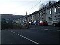
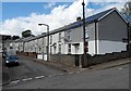
7
Pleasant View, Wattstown
A view WSW along one of several parallel streets on a hillside.
Image: © Jaggery
Taken: 19 Sep 2012
0.13 miles
8
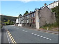
Row of houses, Aberllechau Road, Wattstown
Aberllechau Road skirts the southern edge of Wattstown. A river, the Rhondda Fach,
flows alongside the road, out of shot on the left.
Image: © Jaggery
Taken: 19 Sep 2012
0.13 miles
9
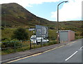
Distances from Wattstown
The signs are alongside Aberllechau Road, opposite the junction for Hillside Terrace and the main residential area of Wattstown. Left for Ynyshir (1 mile) and Porth (1½). Right for Pontygwaith (½), Tylorstown (1½), Ferndale (2¾), Maerdy (5) and Aberdare (9).
The peak (328 metres above mean sea level) is Mynydd Troed-y-rhiw. Image
Image: © Jaggery
Taken: 19 Sep 2012
0.13 miles
10
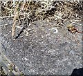
Ordnance Survey Rivet
This OS rivet can be found on the wall south side of Hillside Terrace. It marks a point 152.610m above mean sea level.
Image: © Adrian Dust
Taken: 18 Jun 2017
0.13 miles