IMAGES TAKEN NEAR TO
Victoria Terrace, PORTH, CF39 0PF
Introduction
This page details the photographs taken nearby to Victoria Terrace, CF39 0PF by members of the Geograph project.
The Geograph project started in 2005 with the aim of publishing, organising and preserving representative images for every square kilometre of Great Britain, Ireland and the Isle of Man.

There are currently over 7.5m images from over14,400 individuals and you can help contribute to the project by visiting https://www.geograph.org.uk
Image Map
Images are licensed for reuse under creativecommons.org/licenses/by-sa/2.0
Notes
- Clicking on the map will re-center to the selected point.
- The higher the marker number, the further away the image location is from the centre of the postcode.
Image Listing (51 Images Found)
Images are licensed for reuse under creativecommons.org/licenses/by-sa/2.0
Image
Details
Distance
1
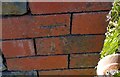
Ordnance Survey Cut Mark
This OS cut mark can be found on the SW face of the Community Hall. It marks a point 163.169m above mean sea level.
Image: © Adrian Dust
Taken: 18 Jun 2017
0.01 miles
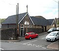
2
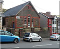
Aberllechau Community Association, Wattstown
The hall is in Victoria Terrace. Aberllechau is the Welsh name for Wattstown.
Image: © Jaggery
Taken: 19 Sep 2012
0.01 miles
3
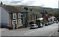
Victoria Terrace, Wattstown
Viewed from the corner of Bryn Terrace.
Image: © Jaggery
Taken: 19 Sep 2012
0.02 miles
6
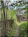
Lane to Tirgwaidd Farm near Wattstown
Arrows on a hillside sign point right towards Tirgwaidd Farm.
Viewed from the Victoria Terrace end of the lane.
Image: © Jaggery
Taken: 19 Sep 2012
0.03 miles
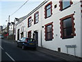
7
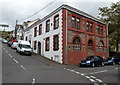
Wattstown Community Centre
The village community centre is at 1 Victoria Terrace. The inscription on the Hillside Terrace
side of the building shows that it was built in 1909 as a Workmen's Institute.
Image: © Jaggery
Taken: 19 Sep 2012
0.04 miles
8
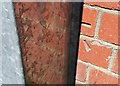
Ordnance Survey Cut Mark
This OS cut mark can be found on the SE face of the Workmen's Institute. It marks a point 154.491m above mean sea level.
Image: © Adrian Dust
Taken: 18 Jun 2017
0.04 miles
9
Aberllechau Primary School, Wattstown
Viewed across School Street. Aberllechau is the Welsh name of Wattstown.
Image: © Jaggery
Taken: 19 Sep 2012
0.04 miles
10
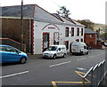
Wattstown Community Centre, Wattstown
Located at the bottom of Victoria Terrace, on the corner of Hillside Terrace. An inscription on the Hillside Terrace side of the building http://www.geograph.org.uk/photo/3586617 shows that it was built in 1909 as a Workmen's Institute.
Image: © Jaggery
Taken: 19 Sep 2012
0.04 miles