IMAGES TAKEN NEAR TO
Upper Gynor Place, PORTH, CF39 0NW
Introduction
This page details the photographs taken nearby to Upper Gynor Place, CF39 0NW by members of the Geograph project.
The Geograph project started in 2005 with the aim of publishing, organising and preserving representative images for every square kilometre of Great Britain, Ireland and the Isle of Man.

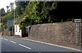
There are currently over 7.5m images from over14,400 individuals and you can help contribute to the project by visiting https://www.geograph.org.uk
Image Map
Images are licensed for reuse under creativecommons.org/licenses/by-sa/2.0
Notes
- Clicking on the map will re-center to the selected point.
- The higher the marker number, the further away the image location is from the centre of the postcode.
Image Listing (41 Images Found)
Images are licensed for reuse under creativecommons.org/licenses/by-sa/2.0
Image
Details
Distance
1
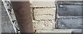
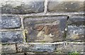
Ordnance Survey Cut Mark
This OS cut mark can be found on No41 Upper Gynor Place. It marks a point 140.857m above mean sea level.
Image: © Adrian Dust
Taken: 24 Jun 2017
0.01 miles
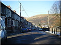
3
Ynyshir Road houses, Ynyshir
A long row of houses on the west side of Ynyshir Road, viewed from the corner of James Terrace. http://www.geograph.org.uk/photo/3139945
Image: © Jaggery
Taken: 19 Sep 2012
0.08 miles
4
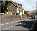
Southern boundary of Ynyshir
Aberrhondda Road from Porth reaches the Rhondda Cynon Taf village of Ynyshir.
Its population on the day of the 2001 Census was 3,442.
Image: © Jaggery
Taken: 19 Sep 2012
0.08 miles
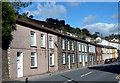
5
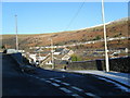
Gynor Place at junction with link to Ynyshir Road
Image: © Colin Pyle
Taken: 4 Jan 2010
0.09 miles
6
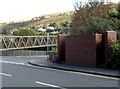
Basic urinal, Ynyshir
Located on the corner of Aberrhondda Road and Llanwonno Road, near a long footbridge. http://www.geograph.org.uk/photo/3139906
The small structure is a basic urinal (no pedestals or wash basins). Though such facilities have largely disappeared from many parts of South Wales, basic urinals (of varying designs) remain a common sight in the Rhondda.
Image: © Jaggery
Taken: 19 Sep 2012
0.09 miles
7
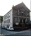
Ynyshir : Moriah Calvinistic Methodist Chapel viewed from the NW
View across Ynyshir Road and Wind Street. The year 1909 is inscribed in stone above
the central first floor window. A notice outside the chapel shows BOYS & YOUTH CLUB.
Image: © Jaggery
Taken: 19 Sep 2012
0.10 miles
8
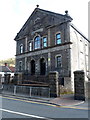
Ynyshir : Moriah Calvinistic Methodist Chapel viewed from the SW
The chapel is on the corner of Ynyshir Road and Wind Street.
The year 1909 is inscribed in stone above the central first floor window.
A notice outside the chapel shows BOYS & YOUTH CLUB.
Image: © Jaggery
Taken: 19 Sep 2012
0.10 miles
9
Northern boundary of Porth
The road south from Ynyshir passes the boundary sign for Porth, a town in the county borough of Rhondda Cynon Taf. Porth's population on the day of the 2001 Census was 5,944.
Image: © Jaggery
Taken: 19 Sep 2012
0.10 miles
10
Ordnance Survey Cut Mark
This OS cut mark can be found on No19 Ynyshir Road. It marks a point 113.154m above mean sea level.
Image: © Adrian Dust
Taken: 24 Jun 2017
0.11 miles