IMAGES TAKEN NEAR TO
Gynor Place, PORTH, CF39 0NR
Introduction
This page details the photographs taken nearby to Gynor Place, CF39 0NR by members of the Geograph project.
The Geograph project started in 2005 with the aim of publishing, organising and preserving representative images for every square kilometre of Great Britain, Ireland and the Isle of Man.

There are currently over 7.5m images from over14,400 individuals and you can help contribute to the project by visiting https://www.geograph.org.uk
Image Map
Images are licensed for reuse under creativecommons.org/licenses/by-sa/2.0
Notes
- Clicking on the map will re-center to the selected point.
- The higher the marker number, the further away the image location is from the centre of the postcode.
Image Listing (49 Images Found)
Images are licensed for reuse under creativecommons.org/licenses/by-sa/2.0
Image
Details
Distance
1
Former Bethel chapel, Ynyshir
Viewed across Ynyshir Road. Now a private residence, formerly a Welsh Baptist chapel.
Image: © Jaggery
Taken: 19 Sep 2012
0.03 miles
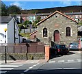
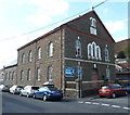
2
Bethany English Baptist Church, Ynyshir
Viewed across Ynyshir Road.
Image: © Jaggery
Taken: 19 Sep 2012
0.04 miles
3
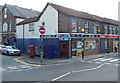
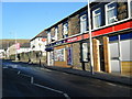
Ynyshir post office
Ynyshir post office is inside a McColl's convenience store at 105 Ynyshir Road.
On the left is the former Saron chapel. http://www.geograph.org.uk/photo/3139983
Image: © Jaggery
Taken: 19 Sep 2012
0.05 miles
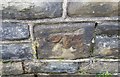
4
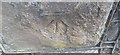
Ordnance Survey Cut Mark
This OS cut mark can be found on the wall of the school on Ynyshir Road. It marks a point 116.751m above mean sea level.
Image: © Adrian Dust
Taken: 24 Jun 2017
0.05 miles
6

Ty Ysgol, Ynyshir
Viewed across Ynyshir Road. Ty Ysgol contains 19 flats.
Image: © Jaggery
Taken: 19 Sep 2012
0.06 miles
7
Former Saron chapel, Ynyshir
Viewed across South Street.
There is a for sale notice on the former chapel, which was built in 1884-1885, with later modifications.
Image: © Jaggery
Taken: 19 Sep 2012
0.06 miles
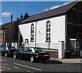
8
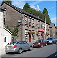
The Ynyshir Hotel, Ynyshir
Viewed across Ynyshir Road. The name banner has the subtitle The Old Pub.
Image: © Jaggery
Taken: 19 Sep 2012
0.08 miles
9
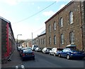
South Street, Ynyshir
A view south along South Street. The former Saron chapel http://www.geograph.org.uk/photo/3139983 is on the right.
Image: © Jaggery
Taken: 19 Sep 2012
0.08 miles
10
Ordnance Survey Cut Mark
This OS cut mark can be found on No19 Ynyshir Road. It marks a point 113.154m above mean sea level.
Image: © Adrian Dust
Taken: 24 Jun 2017
0.09 miles