IMAGES TAKEN NEAR TO
Pleasant Heights, PORTH, CF39 0LZ
Introduction
This page details the photographs taken nearby to Pleasant Heights, CF39 0LZ by members of the Geograph project.
The Geograph project started in 2005 with the aim of publishing, organising and preserving representative images for every square kilometre of Great Britain, Ireland and the Isle of Man.

There are currently over 7.5m images from over14,400 individuals and you can help contribute to the project by visiting https://www.geograph.org.uk
Image Map
Images are licensed for reuse under creativecommons.org/licenses/by-sa/2.0
Notes
- Clicking on the map will re-center to the selected point.
- The higher the marker number, the further away the image location is from the centre of the postcode.
Image Listing (33 Images Found)
Images are licensed for reuse under creativecommons.org/licenses/by-sa/2.0
Image
Details
Distance
1

Ynyshir and Porth from Troed-y-rhiw mountain
Looking south-southeast
Image: © David Spencer
Taken: 23 Jul 2005
0.05 miles
2
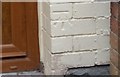
Ordnance Survey Cut Mark
This OS cut mark can be found on No15 Turberville Road. It marks a point 138.891m above mean sea level.
Image: © Adrian Dust
Taken: 24 Jun 2017
0.08 miles
3
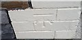
Ordnance Survey Cut Mark
This OS cut mark can be found on No30 Turberville Road. It marks a point 143.256m above mean sea level.
Image: © Adrian Dust
Taken: 24 Jun 2017
0.08 miles
4
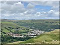
Converging valleys
At the foot of Mynydd Troedyrhiw lies the Welsh valleys town of Porth. Here the two Rhondda rivers, the Rhondda Fawr and the Rhondda Fach, merge before flowing on to Pontypridd where they join the River Taff.
Image: © Alan Hughes
Taken: 6 Jul 2020
0.08 miles
5
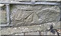
Ordnance Survey Cut Mark
This OS cut mark can be found on No14 Troedyrhiw Road. It marks a point 166.028m above mean sea level.
Image: © Adrian Dust
Taken: 24 Jun 2017
0.08 miles
6
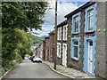
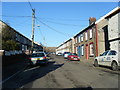
Troedyrhiw Road
Terraced houses in Troedyrhiw Road, Mount Pleasant.
Image: © Alan Hughes
Taken: 6 Jul 2020
0.10 miles
7

Ordnance Survey Cut Mark
This OS cut mark can be found on No3 Troedyrhiw Road. It marks a point 150.285m above mean sea level.
Image: © Adrian Dust
Taken: 24 Jun 2017
0.10 miles
9
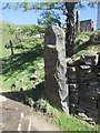
Fine Stone Gatepost
There is an Ordnance Survey cut mark on the bottom of the post. http://www.geograph.org.uk/photo/4435851
Image: © Adrian Dust
Taken: 18 Apr 2015
0.11 miles
10
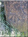
Ordnance Survey Cut Mark
This OS cut mark can be found on the stone gatepost on the bridleway. It marks a point 179.219m above mean sea level. http://www.geograph.org.uk/photo/4435853
Image: © Adrian Dust
Taken: 18 Apr 2015
0.11 miles