IMAGES TAKEN NEAR TO
Station Road, PORTH, CF39 0HA
Introduction
This page details the photographs taken nearby to Station Road, CF39 0HA by members of the Geograph project.
The Geograph project started in 2005 with the aim of publishing, organising and preserving representative images for every square kilometre of Great Britain, Ireland and the Isle of Man.

There are currently over 7.5m images from over14,400 individuals and you can help contribute to the project by visiting https://www.geograph.org.uk
Image Map
Images are licensed for reuse under creativecommons.org/licenses/by-sa/2.0
Notes
- Clicking on the map will re-center to the selected point.
- The higher the marker number, the further away the image location is from the centre of the postcode.
Image Listing (41 Images Found)
Images are licensed for reuse under creativecommons.org/licenses/by-sa/2.0
Image
Details
Distance
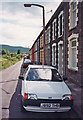
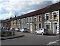
1
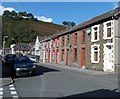
Station Road houses, Ynyshir
Viewed from the corner of William Street.
Image: © Jaggery
Taken: 19 Sep 2012
0.02 miles
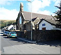
2
St Anne's Church, Ynyshir
Viewed from Station Road. The tower at the far end has 2 bells.
Image: © Jaggery
Taken: 19 Sep 2012
0.03 miles
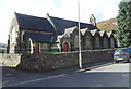
3
St Anne's Church, Ynyshir
Viewed across the A4233 from Railway Terrace.
Image: © Jaggery
Taken: 19 Sep 2012
0.04 miles
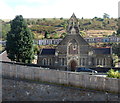
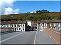
4
St Anne's church and St Anne's memorial hall, Ynyshir
Located on the corner of Church Terrace and Station Road. The memorial hall is the church hall.
Among its various uses is as a polling station for local or national elections.
Image: © Jaggery
Taken: 19 Sep 2012
0.04 miles
5

Ordnance Survey Cut Mark
This OS cut mark can be found on the SE parapet of the bridge over the Afon Rhondda Fach. It marks a point 117.616m above mean sea level.
Image: © Adrian Dust
Taken: 24 Jun 2017
0.04 miles
6

Ordnance Survey Cut Mark
This OS cut mark can be found on the west face of St Ann's Church. It marks a point 119.259m above mean sea level.
Image: © Adrian Dust
Taken: 24 Jun 2017
0.04 miles
7
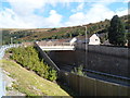
Station Road bridge, Ynyshir
Viewed from Railway Terrace. The bridge crosses over the A4233, formerly the route of a railway line.
Apart from the street names, no trace remains of Ynyshir railway station that was located immediately north of the bridge. The station closed in 1964 on the cessation of passenger services. The line remained open for coal traffic until 1986.
Image: © Jaggery
Taken: 19 Sep 2012
0.05 miles
8
Ynyshir: Railway Terrace in 1993
Looking south along Railway Terrace before the A4233 was built on the alignment of the railway.
Image: © John Sutton
Taken: 10 Jul 1993
0.07 miles
9
Railway Terrace, Ynyshir
Viewed from Station Road. Railway Terrace is alongside, and slightly above,
the A4233 which here follows the route of a former railway.
Image: © Jaggery
Taken: 19 Sep 2012
0.07 miles
10
Railway Terrace and Weston Terrace, Ynyshir
Railway Terrace on the left, Weston Terrace on the right, viewed from Station Road on the bridge over the A4233.
The A4233 follows the route of a former railway.
Image: © Jaggery
Taken: 19 Sep 2012
0.07 miles