IMAGES TAKEN NEAR TO
Penycoedcae Road, PONTYPRIDD, CF38 2FB
Introduction
This page details the photographs taken nearby to Penycoedcae Road, CF38 2FB by members of the Geograph project.
The Geograph project started in 2005 with the aim of publishing, organising and preserving representative images for every square kilometre of Great Britain, Ireland and the Isle of Man.

There are currently over 7.5m images from over14,400 individuals and you can help contribute to the project by visiting https://www.geograph.org.uk
Image Map
Images are licensed for reuse under creativecommons.org/licenses/by-sa/2.0
Notes
- Clicking on the map will re-center to the selected point.
- The higher the marker number, the further away the image location is from the centre of the postcode.
Image Listing (54 Images Found)
Images are licensed for reuse under creativecommons.org/licenses/by-sa/2.0
Image
Details
Distance
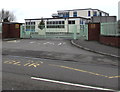
1
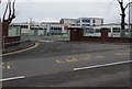
Entrance to Bryn Celynnog Comprehensive School, Beddau
From Penycoedcae Road.
Image: © Jaggery
Taken: 30 Mar 2018
0.01 miles
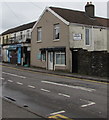
2
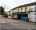
Pizza Time & Charcoal Grill, Beddau
Fast food takeaway (pizza, kebabs, burgers etc) opposite a Penycoedcae Road speed bump.
Image: © Jaggery
Taken: 30 Mar 2018
0.02 miles
3
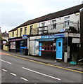
Naz Beddau
Naz Indian cuisine takeaway viewed across Penycoedcae Road in Beddau.
Pizza Time & Charcoal Grill takeaway https://www.geograph.org.uk/photo/5721323 is on the left.
Image: © Jaggery
Taken: 30 Mar 2018
0.02 miles
4
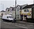
Cross Roads Convenience Store, Beddau
A Premier store viewed across Penycoedcae Road.
Image: © Jaggery
Taken: 30 Mar 2018
0.02 miles
5
Beddau Dental Surgery, 1 The Crossroads, Beddau
Viewed across Penycoedcae Road. Naz https://www.geograph.org.uk/photo/5721326 is on the left.
Image: © Jaggery
Taken: 30 Mar 2018
0.03 miles
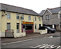
6
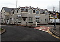
Beddau Community Church, Beddau
An Elim Pentecostal Church on the corner of Castellau Road and Penycoedcae Road.
The building was formerly a pub named The Gelynog.
Image: © Jaggery
Taken: 30 Mar 2018
0.03 miles
7
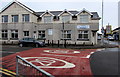
South side of Beddau Community Church, Beddau
The Castellau Road side of the Elim Pentecostal Church on the corner
of Penycoedcae Road. The building was formerly a pub named The Gelynog.
Image: © Jaggery
Taken: 30 Mar 2018
0.03 miles
8
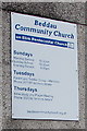
Information notice on the wall of Beddau Community Church, Beddau
Located here https://www.geograph.org.uk/photo/5723521 viewed in March 2018.
Image: © Jaggery
Taken: 30 Mar 2018
0.03 miles
9
Exit from Bryn Celynnog Comprehensive School, Beddau
Into Penycoedcae Road.
Image: © Jaggery
Taken: 30 Mar 2018
0.04 miles
10
Kam Hong, Beddau
Chinese takeaway at 2 Penybryn Cottages, Castellau Road, Beddau.
Image: © Jaggery
Taken: 30 Mar 2018
0.04 miles