IMAGES TAKEN NEAR TO
Heol Coroniad, PONTYPRIDD, CF38 2AT
Introduction
This page details the photographs taken nearby to Heol Coroniad, CF38 2AT by members of the Geograph project.
The Geograph project started in 2005 with the aim of publishing, organising and preserving representative images for every square kilometre of Great Britain, Ireland and the Isle of Man.

There are currently over 7.5m images from over14,400 individuals and you can help contribute to the project by visiting https://www.geograph.org.uk
Image Map
Images are licensed for reuse under creativecommons.org/licenses/by-sa/2.0
Notes
- Clicking on the map will re-center to the selected point.
- The higher the marker number, the further away the image location is from the centre of the postcode.
Image Listing (102 Images Found)
Images are licensed for reuse under creativecommons.org/licenses/by-sa/2.0
Image
Details
Distance
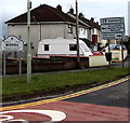
1
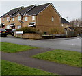
Gospel Court, Beddau
Houses on the corner of Heol Ida and Heol Coroniad.
Image: © Jaggery
Taken: 7 Apr 2018
0.05 miles
2
Tan-y-bryn, Beddau
From Heol Ida along Tan-y-bryn towards Heol-y-Beddau.
Image: © Jaggery
Taken: 7 Apr 2018
0.06 miles
3
Heol Ida, Beddau
This part of Heol Ida is between Heol Coroniad and Tan-y-bryn.
Cwm Coke Works chimneys are in the background https://www.geograph.org.uk/photo/1345631
Image: © Jaggery
Taken: 7 Apr 2018
0.06 miles
4
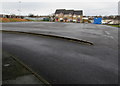
Parking area near Mount Pleasant Park, Beddau
Gospel Court houses are in the background.
Image: © Jaggery
Taken: 7 Apr 2018
0.07 miles
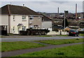
5
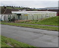
ACF Hut, Heol Ida, Beddau
The Dyfed & Glamorgan ACF (Army Cadet Force) Beddau Detachment hut
is alongside the road named Heol Ida opposite the Tan-y-bryn junction.
Image: © Jaggery
Taken: 7 Apr 2018
0.08 miles
6
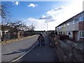
Heol Beddau
A quiet area behind a day centre while being a good area to live with all facilities within just a few minutes walk.
Image: © Derek Cummings
Taken: 10 Feb 2010
0.09 miles
7
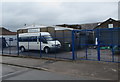
1st Beddau Scout Group hall, Brynhyfryd, Beddau
Image: © Jaggery
Taken: 7 Apr 2018
0.13 miles
8
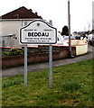
Welcome to/Croeso i/ Beddau
Located here https://www.geograph.org.uk/photo/5721439 at the northern edge of the village in the county borough of Rhondda Cynon Taf, about 3km from Llantrisant and 7km from Pontypridd. The local pronunciation of the village name by English speakers is similar to Bather. The literal meaning of the Welsh Beddau is Graves or Tombs. The reason for the name is obscure - one possibility is that this area was an ancient (pre-Christian) burial site.
Image: © Jaggery
Taken: 30 Mar 2018
0.14 miles
9
Directions sign at the northern edge of Beddau
Alongside Penycoedcae Road a few metres from the Welcome to/Croeso i Beddau sign https://www.geograph.org.uk/photo/5721466 on the left.
Image: © Jaggery
Taken: 30 Mar 2018
0.14 miles
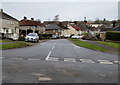
10
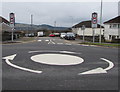
Mini-roundabout at the northern edge of Beddau
At the junction of Penycoedcae Road and Heol-y-Beddau (ahead).
Image: © Jaggery
Taken: 30 Mar 2018
0.14 miles