IMAGES TAKEN NEAR TO
Nant Y Felin, PONTYPRIDD, CF38 1YY
Introduction
This page details the photographs taken nearby to Nant Y Felin, CF38 1YY by members of the Geograph project.
The Geograph project started in 2005 with the aim of publishing, organising and preserving representative images for every square kilometre of Great Britain, Ireland and the Isle of Man.

There are currently over 7.5m images from over14,400 individuals and you can help contribute to the project by visiting https://www.geograph.org.uk
Image Map
Images are licensed for reuse under creativecommons.org/licenses/by-sa/2.0
Notes
- Clicking on the map will re-center to the selected point.
- The higher the marker number, the further away the image location is from the centre of the postcode.
Image Listing (6 Images Found)
Images are licensed for reuse under creativecommons.org/licenses/by-sa/2.0
Image
Details
Distance
1
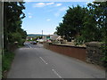
Bridge over former railway line in Efail Isaf
Image: © Gareth James
Taken: 4 Jun 2011
0.09 miles
2
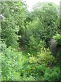
Route of former railway line in Efail Isaf
Image: © Gareth James
Taken: 4 Jun 2011
0.11 miles
3
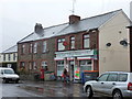
Efail Isaf: the post office
A man leaves the village store and post office on a very wet morning. The sign outside the door says that the post office is now open from 7am Monday to Saturday, having previously opened at the more conventional time of 9 o'clock.
Image: © Chris Downer
Taken: 18 Feb 2012
0.15 miles
4
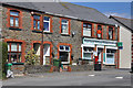
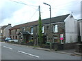
Village Store and Post Office - Efail Isaf
Image: © Mick Lobb
Taken: 20 Apr 2010
0.16 miles
5
Heol Ffrwd Philip
Stone terraces in Efail Isaf.
Image: © Burgess Von Thunen
Taken: 11 Aug 2012
0.18 miles
6
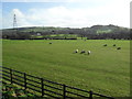
Farmland near Efail Isaf
Adjacent to the Church Village bypass.
Image: © Burgess Von Thunen
Taken: 26 Jan 2012
0.23 miles