IMAGES TAKEN NEAR TO
Dyffryn Y Coed, PONTYPRIDD, CF38 1PQ
Introduction
This page details the photographs taken nearby to Dyffryn Y Coed, CF38 1PQ by members of the Geograph project.
The Geograph project started in 2005 with the aim of publishing, organising and preserving representative images for every square kilometre of Great Britain, Ireland and the Isle of Man.

There are currently over 7.5m images from over14,400 individuals and you can help contribute to the project by visiting https://www.geograph.org.uk
Image Map
Images are licensed for reuse under creativecommons.org/licenses/by-sa/2.0
Notes
- Clicking on the map will re-center to the selected point.
- The higher the marker number, the further away the image location is from the centre of the postcode.
Image Listing (4 Images Found)
Images are licensed for reuse under creativecommons.org/licenses/by-sa/2.0
Image
Details
Distance
2
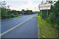
Church Village
Welcome to Church Village, Station Road.
Image: © Stuart Lang
Taken: 8 Jun 2019
0.18 miles
3
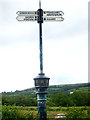
Cycleway sign post
Situated on the cycleway next to the Church Village by-pass, this sign shows some extreme destinations
Image: © John Finch
Taken: 18 Jun 2014
0.21 miles
4

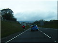
Small parking area by roundabout on A473
Image: © David Smith
Taken: 17 Sep 2022
0.23 miles