IMAGES TAKEN NEAR TO
Church Road, PONTYPRIDD, CF38 1EG
Introduction
This page details the photographs taken nearby to Church Road, CF38 1EG by members of the Geograph project.
The Geograph project started in 2005 with the aim of publishing, organising and preserving representative images for every square kilometre of Great Britain, Ireland and the Isle of Man.

There are currently over 7.5m images from over14,400 individuals and you can help contribute to the project by visiting https://www.geograph.org.uk
Image Map
Images are licensed for reuse under creativecommons.org/licenses/by-sa/2.0
Notes
- Clicking on the map will re-center to the selected point.
- The higher the marker number, the further away the image location is from the centre of the postcode.
Image Listing (5 Images Found)
Images are licensed for reuse under creativecommons.org/licenses/by-sa/2.0
Image
Details
Distance

2

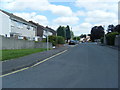
Public Convenience Tonteg
Located near Tonteg Park.
Image: © Duncan and Gareth Alderson
Taken: 31 Jul 2007
0.12 miles
3
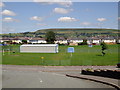
Tonteg Park viewed from Cedar Crescent
In the foreground is the football stand, beyond this can be seen Maesteg Gardens and in the distance is the Eglwysilan mountain.
Image: © Duncan and Gareth Alderson
Taken: 31 Jul 2007
0.15 miles
5
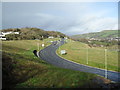
Church Village Bypass
Main Road as it climbs away from the roundabout at the north end of the bypass.
Image: © Burgess Von Thunen
Taken: 26 Jan 2012
0.24 miles