IMAGES TAKEN NEAR TO
Efail Isaf, PONTYPRIDD, CF38 1BH
Introduction
This page details the photographs taken nearby to CF38 1BH by members of the Geograph project.
The Geograph project started in 2005 with the aim of publishing, organising and preserving representative images for every square kilometre of Great Britain, Ireland and the Isle of Man.

There are currently over 7.5m images from over14,400 individuals and you can help contribute to the project by visiting https://www.geograph.org.uk
Image Map
Images are licensed for reuse under creativecommons.org/licenses/by-sa/2.0
Notes
- Clicking on the map will re-center to the selected point.
- The higher the marker number, the further away the image location is from the centre of the postcode.
Image Listing (10 Images Found)
Images are licensed for reuse under creativecommons.org/licenses/by-sa/2.0
Image
Details
Distance
1
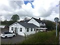
The Ship Inn
The Ship Inn - pub and restaurant in Llantwit Fardre.
Image: © Alan Hughes
Taken: 25 Apr 2018
0.01 miles
2
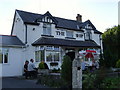
The Ship Inn
Situated at the junction of roads to Efail Isaf, Llantwit Fardre, Creigiau and Rhiwsaeson.
Image: © Duncan and Gareth Alderson
Taken: 31 Jul 2007
0.02 miles
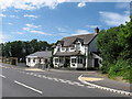
5
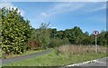
Cycle path along by A473 south of Llantwit Fardre
Image: © David Smith
Taken: 17 Sep 2022
0.18 miles
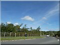
6
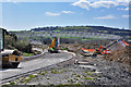
Bypass and bridge under construction - Efail Isaf
The bypass passes north of Efail Isaf to avoid the conurbations of Beddau, Llantwit Fardre and Church Village.
Image: © Mick Lobb
Taken: 20 Apr 2010
0.20 miles
8
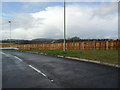
Church Village Bypass
Noise mitigation fence on Heol Dowlais.
Image: © Burgess Von Thunen
Taken: 26 Jan 2012
0.22 miles
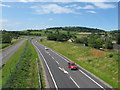
9
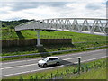
Footbridge over the new A473
Part of the Church Village bypass.
Image: © Gareth James
Taken: 4 Jun 2011
0.24 miles
10
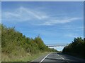
Footbridge over A473
This provides a short route between Efail Isaf and Llantwit Fardre;
Image: © David Smith
Taken: 17 Sep 2022
0.24 miles