IMAGES TAKEN NEAR TO
Parc Nant Celyn, PONTYPRIDD, CF38 1AJ
Introduction
This page details the photographs taken nearby to Parc Nant Celyn, CF38 1AJ by members of the Geograph project.
The Geograph project started in 2005 with the aim of publishing, organising and preserving representative images for every square kilometre of Great Britain, Ireland and the Isle of Man.

There are currently over 7.5m images from over14,400 individuals and you can help contribute to the project by visiting https://www.geograph.org.uk
Image Map
Images are licensed for reuse under creativecommons.org/licenses/by-sa/2.0
Notes
- Clicking on the map will re-center to the selected point.
- The higher the marker number, the further away the image location is from the centre of the postcode.
Image Listing (9 Images Found)
Images are licensed for reuse under creativecommons.org/licenses/by-sa/2.0
Image
Details
Distance
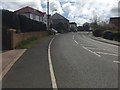
1
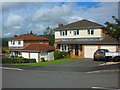
Parc Nant Celyn
2000s houses in Efail Isaf.
Image: © Burgess Von Thunen
Taken: 11 Aug 2012
0.09 miles
2

Parc Nant Celyn
Housing in Parc Nant Celyn, Efail Isaf.
Image: © Alan Hughes
Taken: 25 Apr 2018
0.12 miles
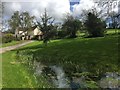
3

Nant y Celyn playground
Children's playground at Nant y Celyn.
Image: © Alan Hughes
Taken: 25 Apr 2018
0.13 miles
5
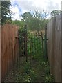
Public footpath
Kissing gate on public footpath between houses in Efail Isaf.
Image: © Alan Hughes
Taken: 25 Apr 2018
0.18 miles
7
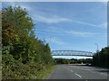
Footbridge over A473 south of Llantwit Fardre
It provides a safe route across the main road avoiding the roundabout
Image: © David Smith
Taken: 17 Sep 2022
0.22 miles
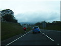
8

Small parking area by roundabout on A473
Image: © David Smith
Taken: 17 Sep 2022
0.24 miles